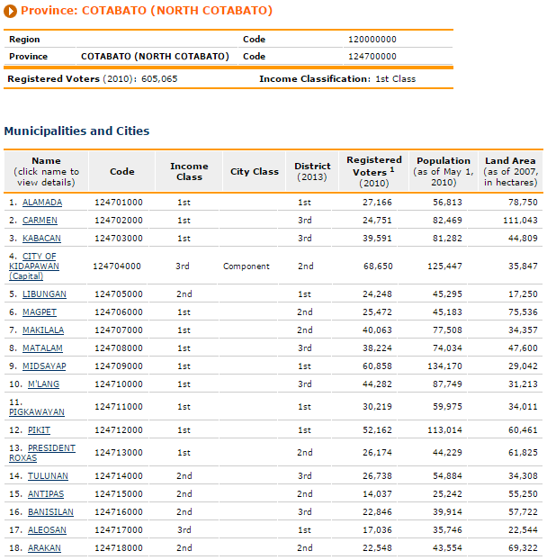
An Overview
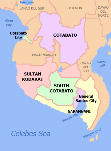
SOCCSKSARGEN also known as Region XII is located in Central Mindanao. The name of the region is an acronym that stands for the region’s four provinces and one of its cities: South Cotabato, Cotabato, Sultan Kudarat, Sarangani and General Santos. The region used to be called Central Mindanao. The regional center is Koronadal located in the province of South Cotabato, and the center of commerce, industry, transportation and the most populous city is General Santos.
Soccsksargen encompasses Cotabato City situated within the borders of Maguindanao, a province of the Autonomous Region in Muslim Mindanao (ARMM). SOX is the region’s nickname that is intended for marketing promotions and easy recall. The region is branded as the 12th paradise of the Philippines.
Retrieved from https://upload.wikimedia.org/wikipedia/commons/5/5a/Ph_SOCCSKSARGEN.png
For a more detailed map, click here (Google map).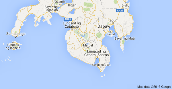
For the terrain/topographical map, click here.
http://www.maphill.com/philippines/region-12/detailed-maps/terrain-map/
History
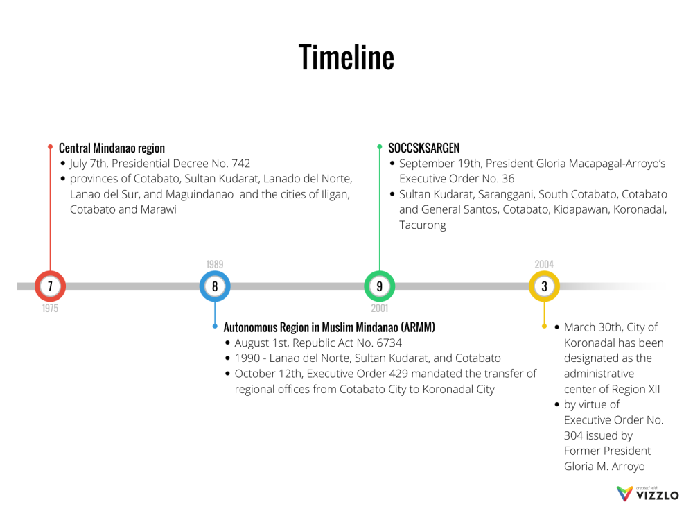
- 1975 – July 7th, Region XII or the Central Mindanao region was created under Presidential Decree No. 742 composed of the provinces of Cotabato, Sultan Kudarat, Lanado del Norte, Lanao del Sur, and Maguindanao and the cities of Iligan, Cotabato and Marawi
- 1989 – August 1st, Republic Act No. 6734 provided for the creation of the Autonomous Region in Muslim Mindanao (ARMM)
- 1990 – Central Mindanao was left with Lanao del Norte, Sultan Kudarat, and Cotabato due to the creation of Autonomous Region in Muslim Mindanao
- October 12th, Executive Order 429 mandated the transfer of regional offices from Cotabato City to Koronadal City
- 1995 – February 23rd, Republic Act 7901 ‘An act Creating Region XIII to be known as the Caraga Administrative Region, and for other Purpose’ was enacted. Section 3 of thee said law provided for the transfer of Sultan Kudarat to Region XI
- 1998 – March 21st, the municipality of Kidapawan became a city with the enactment of Republic Act 8500; the Province of Sultan Kudarat was reverted to Region XII by virtue of Republic Act 8744
- 2000 – August 16th, the municipality of Koronadal became a city through Republic Act No. 8803; September 18th, the municipality of Tacurong in the Sultan Kudarat became a city by virtue of Republic Act o. 8805
- 2001 – September 19th, President Gloria Macapagal-Arroyo’s Executive Order No. 36 reorganized the regions and provinces in Mindanao. This move changed Region XII into the present SOCCSKSARGEN. Region XII is now composed of the provinces of Sultan Kudarat, Saranggani, South Cotabato and Cotabato Province and the cities of General Santos, Cotabato, Kidapawan, Koronadal, and Tacurong.
- 2004 – March 30th, the City of Koronadal has been designated as the administrative center of Region XII by virtue of Executive Order No. 304 issued by Former President Gloria M. Arroyo
Geography
The region is bounded on the north by Northern Mindanao, on the east by the Davao Region, and on the southwest by the Celebes Sea. The province of Maguindanao is situated between Cotabato City, Cotabato province and Sultan Kudarat.
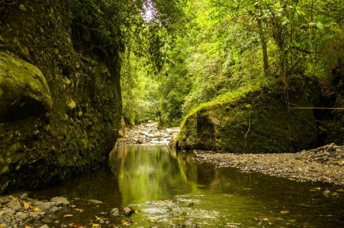
The region has extensive coastlines, valleys and mountain ranges. Known for its river system, the region is the catch basin of Mindanao, particularly at the Cotabato Basin, a large depression surrounded by mountain ranges on three sides. Within the basin runs the Rio Grande de Mindanao, the longest river in Mindanao and the second longest in the Philippines. The river empties into the Illana Bay of the larger Moro Gulf at the west of Cotabato City. At the south of the basin lie the Tiruray Highlands, a moderately high mountain range blocking the basin from the southern coastline. Southeast of the mountains lie the Sarangani Bay.
Land Area
Region XII has a total land area of 19,165.87 sq. km., which is about 17% that of Mindanao . Among the four provinces of the region, North Cotabato has the biggest area at 6,019.78 sq. km. It is about 30.4% of the region’s area. The smallest among the provinces is Sultan Kudarat with an area of 4,401.06 sq. km.
Among the five cities of the region, General Santos City has the biggest land area at 668.49 sq. km., with Tacurong City as the smallest at 161.96 sq. km.
Climate
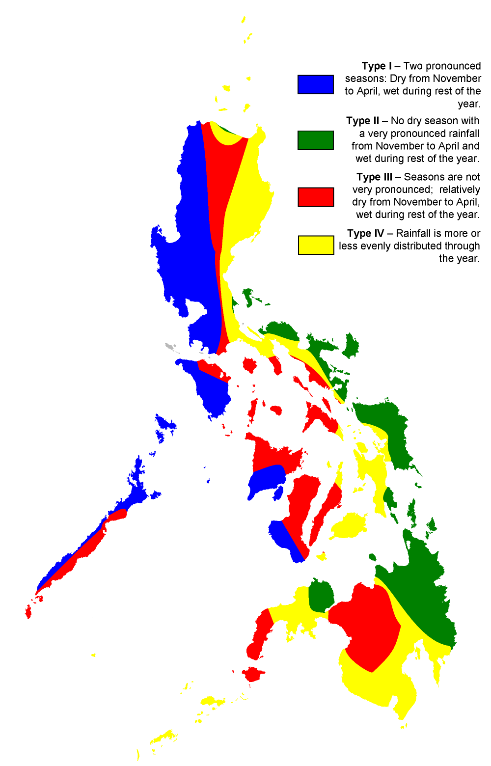
According to the Philippine climate system established by Coronas, most parts of Region XII have a Type IV climate:
| Type Ⅳ | Rainfall is more or less evenly distributed throughout the year. |
While some parts have a Type III climate:
| Type Ⅲ | Seasons are not very pronounced, relatively dry from November to April, and wet during the rest of the year. |
Retrieved from https://upload.wikimedia.org/wikipedia/commons/9/94/Philippine_climate_map.png
Population
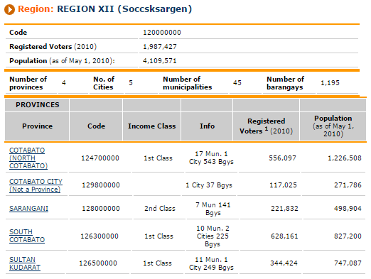
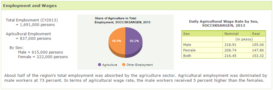
The population of Region XII as of May 2010 stood at 4.11 million persons, placing it at 10th rank among the heavily populated regions nationwide. It registered a 2.46% population growth rate (PGR) for the period 2000-2010, making it 2nd among five regions in the country with PGR higher than the National PGR of 1.90% annually.
Among the provinces, Cotabato (North) Province had the largest population with 1.227 million. South Cotabato placed second with 827,200; Sultan Kudarat and Sarangani came into 3rd and 4th with 747,087 and 489,904 respectively. For the cities, General Santos City recorded a 538,086 population ( 13% of Region XII’s total population), while Cotabato City had the total population of 271,786.
Retrieved from http://www.nscb.gov.ph/activestats/psgc/regview.asp?region=12
Economy
- as of 2013
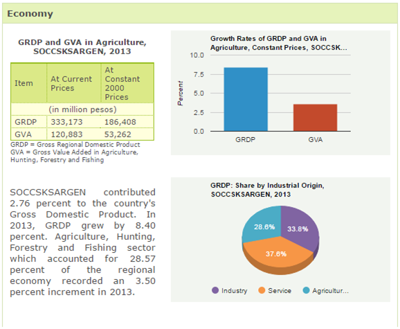
Retrieved from http://countrystat.psa.gov.ph/?cont=16&r=12
A Closer Look: Provinces and Cities
COTABATO CITY – Independent City
- Barangays
- Mother Barangay Rosary Heights
- Barangay Rosary Heights No. 1
- Barangay Rosary Heights No. 2
- Barangay Rosary Heights No. 3
- Barangay Rosary Heights No. 4
- Barangay Rosary Heights No. 5
- Barangay Rosary Heights No. 6
- Barangay Rosary Heights No. 7
- Barangay Rosary Heights No. 8
- Barangay Rosary Heights No. 9
- Barangay Rosary Heights No. 10
- Barangay Rosary Heights No. 11
- Barangay Rosary Heights No. 12
- Barangay Rosary Heights No. 1
- Mother Barangay Tamontaka
- Barangay Tamontaka No. 1
- Barangay Tamontaka No. 2
- Barangay Tamontaka No. 3
- Barangay Tamontaka No. 4
- Barangay Tamontaka No. 5
- Mother Barangay Bagua
- Barangay Bagua No. 1
- Barangay Bagua No. 2
- Barangay Bagua No. 3
- Mother Barangay Poblacion
- Barangay Poblacion No. 1
- Barangay Poblacion No. 2
- Barangay Poblacion No. 3
- Barangay Poblacion No. 4
- Barangay Poblacion No. 5
- Barangay Poblacion No. 6
- Barangay Poblacion No. 7
- Barangay Poblacion No. 8
- Barangay Poblacion No. 9
- Mother Barangay Kalanganan
- Barangay Kalanganan No. 1
- Barangay Kalanganan No. 2
- Mother Barangay Rosary Heights
History/Trivias/Intro
- The name Cotabato came from “Kuta” which means fort and “Wato” which means stone. .
- Independent chartered city
- Within the boundaries of the province of Maguindanao. Politically autonomous from the province of Maguindanao.
- Seat of the ARMM regional government although being part of Region XII
- Settlements started as early as 1475. Under the reign of Sultan Dipatwan Qudarat, the place developed as the capital town of Mindanao during the seventeenth century.
- Nineteenth Century: Roads and wharves were constructed which gave rise to the birth of modern day Cotabato when Sultan Makakua ruled
- Enticed the inhabitants from Zamboanga and Visayas to migrate and settle to Cotabato
- Twentieth Century: During when Americans started to rule the Philippines, Cotabato became the capital town of Cotabato province.
- June 20, 1959 : By virtue of Republic Act No. 2364, Cotabato City was declared a chartered city
Land Area
- Land Area: 17, 599 Hectares or 6795 square miles
Population
- 271,786 (As of May 1, 2010)
Tourism
- 2016 is Tourism Awareness Year for Cotobato City
- A program that will officially commence on April 25 2016 with the program Linisin natin ang Kapitolyo which is a clean-up drive at the Old City Hall and the City Plaza grounds.
- The City’s Tourism Officer, Norianne Lou Frondoza, said that there is a growing need to institutionalize Cotabato City as one of the top tourist destinations not only in Region 12, but in the whole country as well.
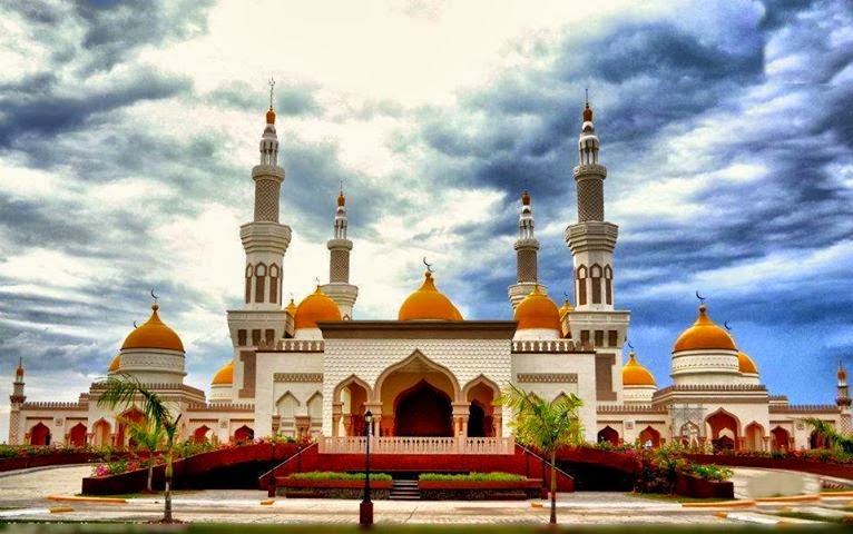
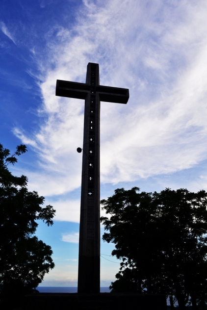
- Grand Mosque
- Rests by the Tamontaka River and Moro gulf
- A surreal site that juts out the coastal village of Inawan.
- The largest and most exquisitely designed mosque in the country
- Built through generous donations from Filipinos and through the aid of Masjid Sultan Hassanal Bolkiah, Sultan of Brunei.
- As high as a 15-storey building with golden top and minarets
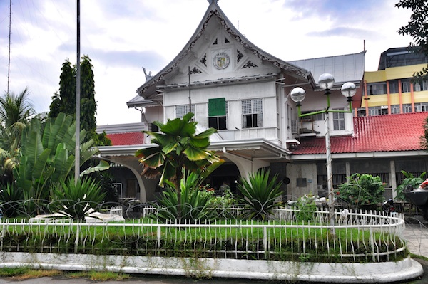
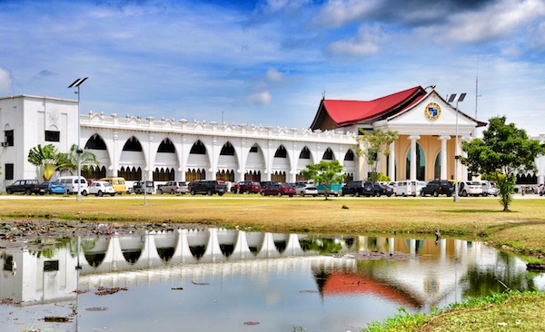
- People’s Palace
- Old City Hall
- New City Hall
- Old City Hall
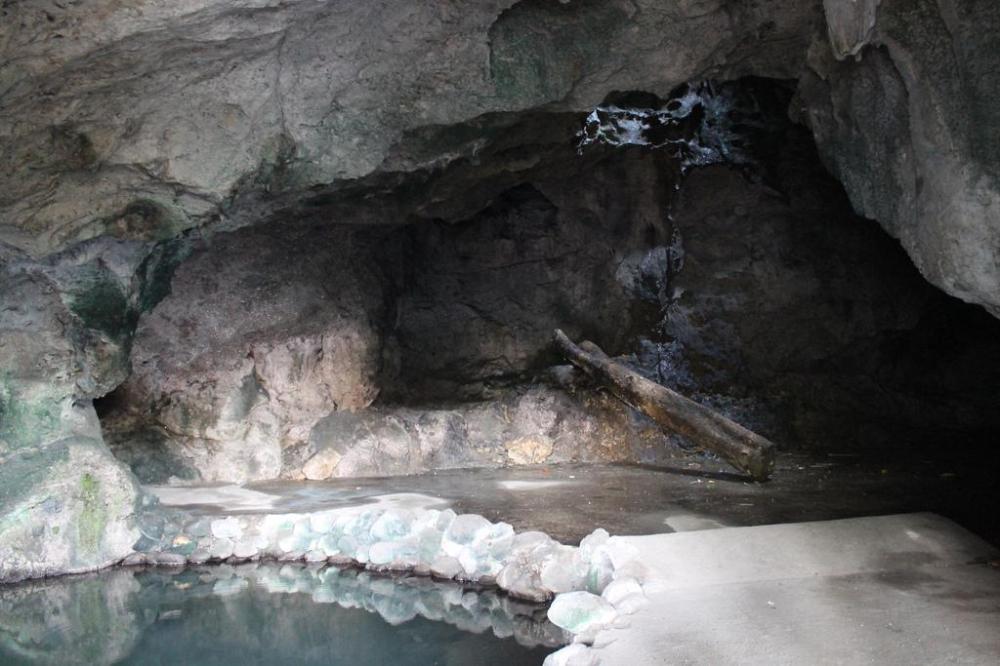
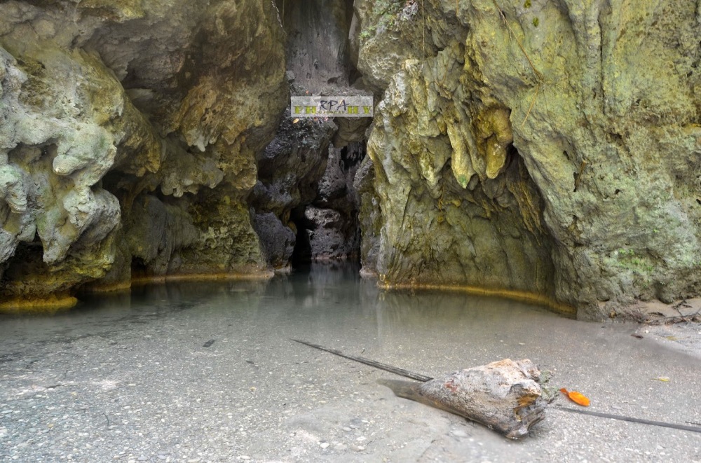
- Kutawato Cave Complex
- Located in the center of the city’s traffic and has various entrances
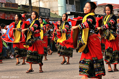
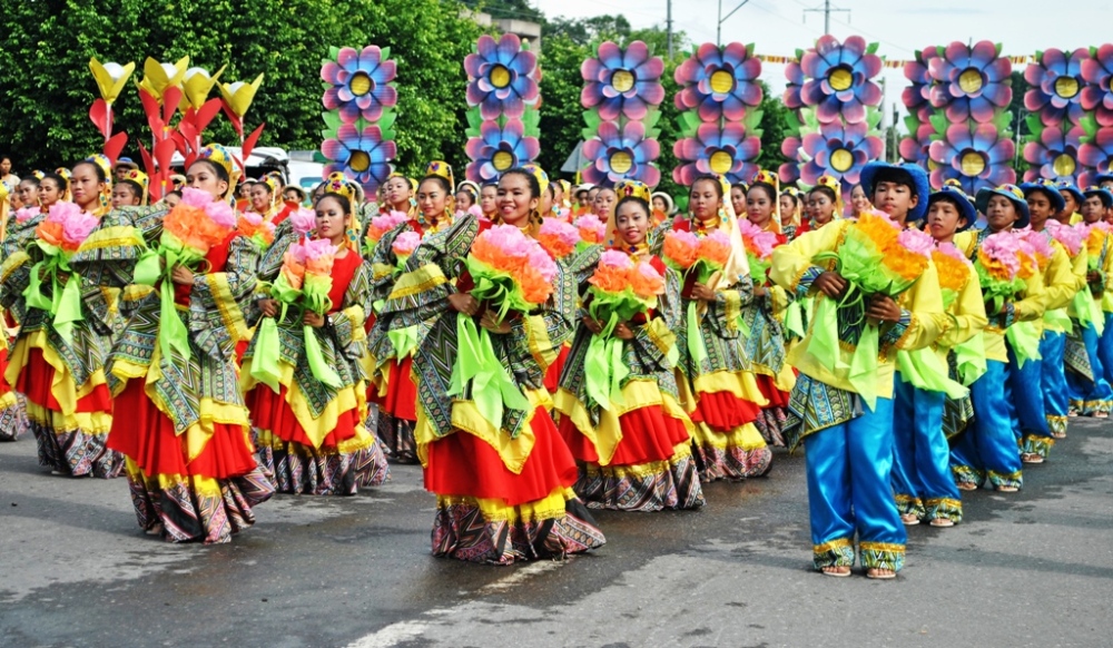
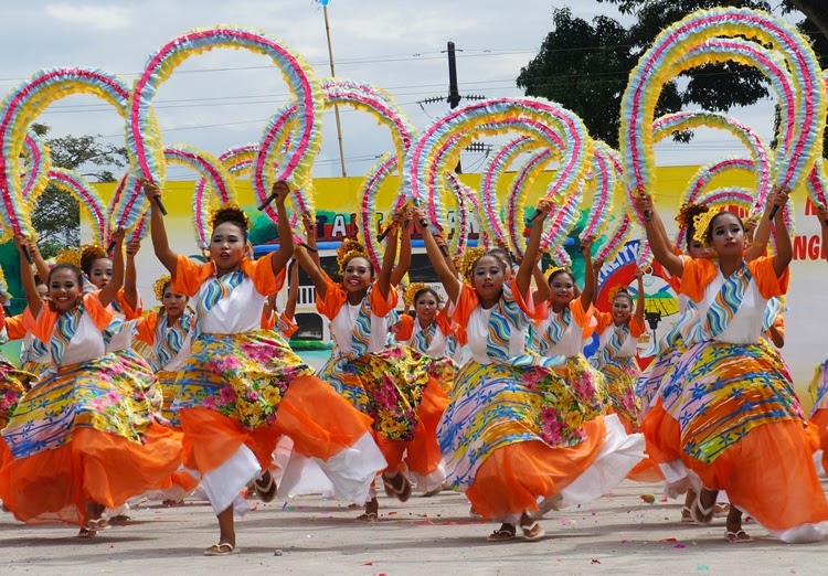
Culture/Events
- Majority of the city’s population is Muslim, comprising about 80% of the population. The majority of Muslims in Cotabato City are Sunnites. The majority of Christians in Cotabato City are Roman Catholics, most of whom are Cebuanos and Chavacanos.
- Araw ng Kutabato
- Celebrated from June 12th to June 25th
- Biggest celebration in all of Cotabato’s city festivals
- Commemorates the city’s charter anniversary
- Celebrates events such as agri-aqua product showcase, exhibits of photographs and artworks, sports and traditional games
- Celebrates mammoth civic/military and cultural dance parade known as Lilang-lilang Festival
- Celebration finale is the selection of the city’s fairest maiden in the search for the “Mutya ng Kutabato”
- Our Lady of Peñafrancia Fiesta
- Celebrated on 3rd Sunday of September
- Celebrated in honor of Our Lady of Peñafrancia
- Preceded with a Holy mass and procession from the Immaculate Conception Cathedral to a waiting landing craft (barge) decked with colorful buntings, banana trunks, flowers and a brass band for its traditional fluvial procession at the Rio Grande to watch or join the procession in fulfillment of a vow, hosted by the Bicolano Association of Cotabato City
- A replica of the same event in Naga City.
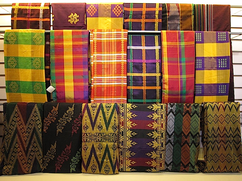
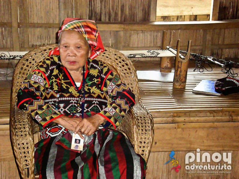
- Inaul
- Showcases the fine craftsmanship of the people in Cotabato City through this weaving tradition
- Worn by men and women as malong and head pieces
- Such designs are makabimban and sinukimpan
- Orange and yellow signifies royalty
- Green signifies peace
Geographical/Environmental Aspects
- Elevation: 17 meters
- Latitude: 07°14ˈN
- Longitude: 124°15ˈE
- Köppen Classification: Tropical Rainforest Climate
- Tropical rainforest climate is a type of tropical climate in which there is no dry season – all months have mean precipitation values of at least 60 mm (2.36 in). Tropical rainforest climates have no pronounced summer or winter; it is typically hot and wet throughout the year and rainfall is both heavy and frequent. One day in an equatorial climate can be very similar to the next, while the change in temperature between day and night may be larger than the average change in temperature between “summer” and “winter”.
- Average Annual Temperature: 27.2°C/81.0°
- Warmest month: March (Average Temperature : 27.8°C/82.0°F
- Coolest month: January (Average Temperature: 26.7°C/80.0°F
- The highest recorded temperature is 37.2°C/99.0°F which was recorded in March.
- The lowest recorded temperature is 16.1°C/61.0°F, which was recorded in January.
- Average Amount of Precipitation: 85.1 in/2161.5 mm). Average of 131.3 days of rain annually
- Month with most precipitation: August (Average Precipitation: 12.9 in /327.7 mm)
- Month with the least precipitation: January (Average Precipitation: 2.5 in/63.5 mm)
Politics
- Mayor – Hon. Japal J. Guiani, Jr.
- Vice Mayor – Hon. Atty. Frances Cynthia Guiani-Sayadi
- Councilors
- Graham Nazer G. Dumama
- Bruce Matabalao
- Michael Datumanong
- Sukarno Sema
- Abdillah J. Lim
- Ed Rabago
- Freddie Ridao
- Johari Abu
- Hassan Biruar
- Christina Chua
Provinces
SARANGANI
- Named after Sarangani Bay
- Sarangani came from the legend of Saranganing, an adventurous son of a Sangil famlily from the coast of Celebes off Indonesia whose voyages often brought him to the Sultanate of Buayan (present day General Santos City), the stronghold of the Maguindanaoans. His outstanding character impressed the people so they named the bay in his honor.
- Capital: Alabel
- Sarangani is subdivided into 7 municipalities grouped into two parts, separated by the Sarangani Bay. The western part consists of Kiamba, Maasim, and Maitum, while the eastern part is composed of Alabel, Glan, Malapatan, and Malungon.
History/Trivias/Intro
- 1543
- Sarangani was named by Ruy López de Villalobos as Antonia in honor of Antonio de Mendoza y Pacheco who commissioned Villalobos expedition to the Philippines
- The first inhabitants were called “MunaTo”, a native term for “first people”
- 1942
- Japanese troops occupied modern day Sarangani
- 1945
- Filipino troops of the 6th, 10th, 101st and 102nd Infantry Division of the Philippine Commonwealth Army and 10th Infantry Regiment of the Philippine Constabulary entered and liberated in modern day Sarangani and fought against the Japanese Imperial Army forces during the Battle of Cotabato at the end of World War II under the Japanese Occupaton
- 1966
- Sarangani was incorporated into the province of South Cotabato
- March 16, 1992:
- Republic Act 7228 authored by Rep. James L. Chiongbian established Sarangani as an independent province.
- Chiongbian’s wife, Priscilla L. Chiongbian, was the first Governor of Sarangani. They are known as the Father and Mother of Sarangani Province
Land Area
- 360,125 Hectares or 45 square miles
Population
- 498,904
Tourism
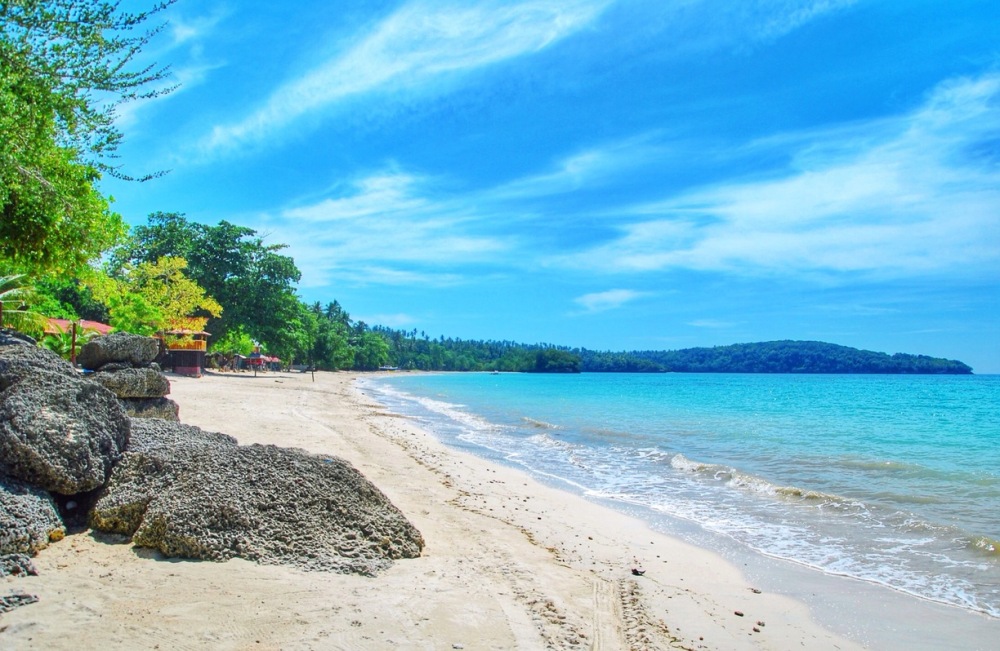
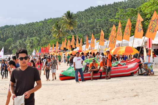
- Gumasa Beach
- Located at Glan, Sarangani
- “Boracay of Mindanao”
- A long stretch of powdery white sand beaches
- River Pangi
- Lamlifew Village
- Lamlifew School of Living Tradition is found here. It has been attracting visitors from all over the world for it showcases the Blaan tradition especially its amazing craftsmanship.
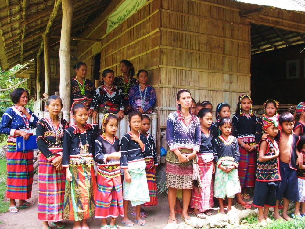
- Helen Lacna Lumbos, president of the Lamlifew Tribal Women’s Association, together with the women and children, welcomes visitors in traditional clothing
- Nalus Falls
- Natural scenic view in Kiamba
- Has huge boulders of granite giving to a number of water falls, ideal for
scrambling, bouldering and rappelling. 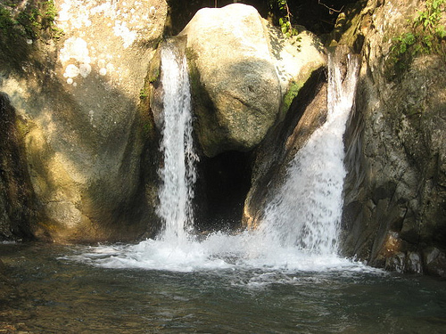
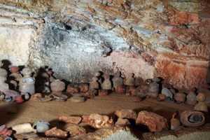
- Pinol Cave
- Formerly known as Ayub Cave
- A unique assemblage of archaeological find that depicts Sarangani’s cultural wealth which was excavated in this cave in 1991 is found
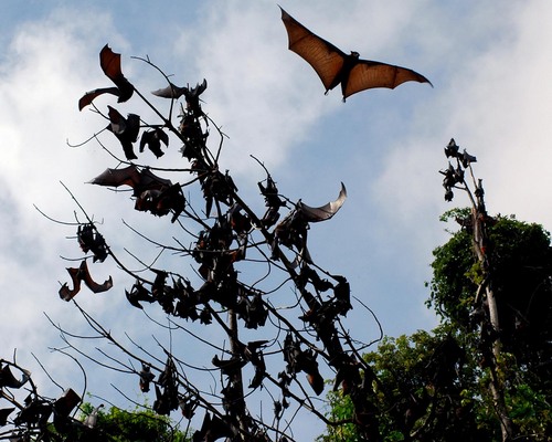
- Bat Sanctuary
- Situates hundreds of thousands of giant golden crowned flying fox bats
- Tampat Shrine
- Situates the majestic shrine of the subordinate ruling Sultanates of Maguindanao
- Kalon-Barak Skyline
- A viewing point of Mt. Apo, Mt. Matutum, Sarangani Bay and Davao Gulf
- Habitat ofSarangani tarsiers
- Holds 3 villages of B-laan tribe. It is the tribes’ last stronghold
during the Japanese occupation.
Culture/Events
- Sarangani Bay Festival
- Known to the locals as Sarbay Fest
- An annual event in Sarangani held every third week of May
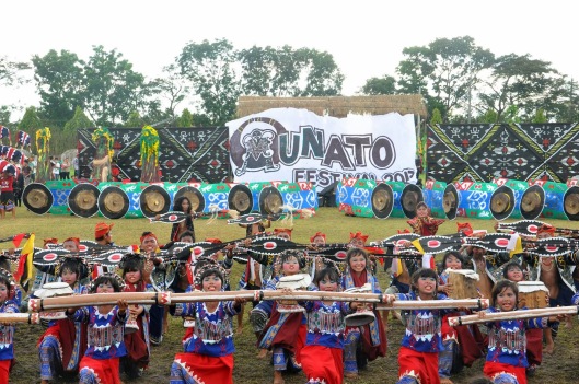
- Munato Festival
- Celebrates the foundation of Sarangani Province
- Held every 30th day of November
Geographical/Environmental Aspects
- Latitude: 5°52′N
- Longitude: 125°17′E
- Warmest month: April (Average Temperature of 27.5°C)
- Coolest Month: July (Average Temperature of 26.3°C)
- Köppen Climate Classification: Af
- Average Annual Rainfall: 1752 mm
- Driest Month: September (114 mm average amount of rainfall)
- Month with most precipitation: January (169 mm average amount of rainfall)
- Average Temperature: 26.8°C
Politics
- Governor – Steve Solon
- Vice Governor – Elmer De Peralta
- Representatives
- Lone District – Rogelio Pacquiao
- Board Member
- 1st District – George Falgui
- 2nd District – Cyril John Rustico Yap
SOUTH COTABATO
- Land of dreamweavers
- The patterns they use to weave are those that came from their dreams
- Home of the T’bolis
- Provincial Capital : Koronadal City
- Territorial Composition : 2 Districts
- District I
- Tampakan
- Tupi
- Polomolok
- District II
- Banga
- Surallah
- Niño
- T’boli
- Lake Sebu
- Tantangan
- Norala
- Koronadal City
- District I
History/Trivias/Intro
- Before 20th century: the area where South Cotobato lies is inhabited by Muslims, B’laans, Manobos, Tagabiils and other ethnic groups who migrated to this part of Mindanao.
- February 27, 1939: Pioneers mostly coming from Luzon led by the late General Paulino Santos arrived and laid the foundation for what was to become the progressive province it is today
- July 18, 1966: South Cotabato was formed as an independent province from Cotabato
Land Area
- 442 881 Hectares or 1709.97 miles
Population
- 827,200
Tourism
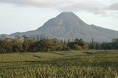
- Matutum
- Has a height of 2,286 meters above sea level
- Stands as the landmark of the SOCCSKSARGEN region
- Located at the boundaries of the Municipality of Tupi, Tampakan and Polomok in South Cotabato Province, and Malungon in Sarangani Province
- Parker Ranges and Lake Maughan
- Located at T’boli.
- Parker’s peak known as Asamblak peak is at 1750 meters above sea level.
- The Maughan Lake is the crater lake of Mt. Parker which is estimated to be 300 ha wide
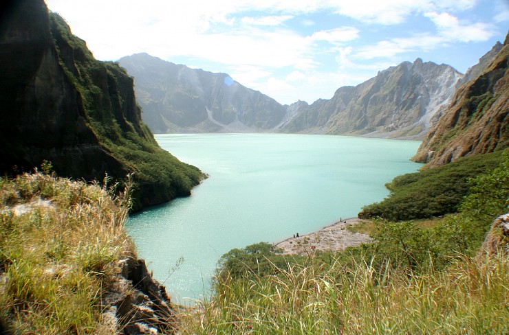
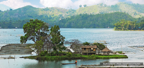
- Lake Sebu
- Consists of islets and a large body of water which is 365 ha wide and surrounded by rolling hills and mountains
- Seven Falls in Lake Sebu
- Hikong Alo
- Hikong Bente
- Hikong B’Lebel “Coil/Zigzag”
- Hikong Lowig “Booth”
- Hikong Ukol “Wild Flower”
- Hikong K’Fo-I “Short”
- Hikong Tonok “Soil”
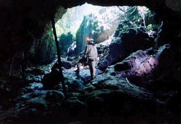
- Salkak Caves 1 & 2
- A 222-meter cave that has a 30-meter vertical pit and a chamber with an open pit above.
- Located in Landan, Polomolok, South Cotabato
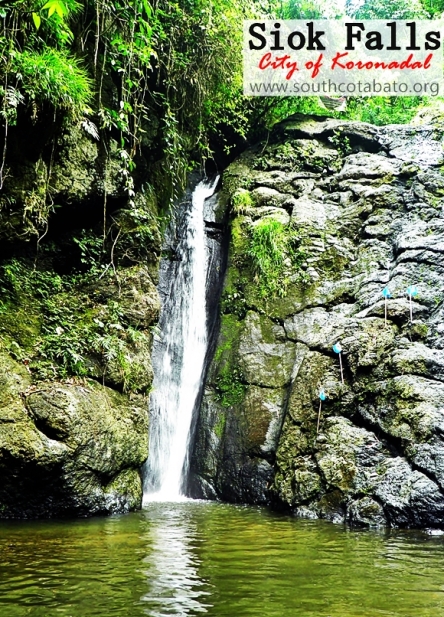
- Siok Waterfalls
- A 70-feet falls
- .
Personalities
- Kenneth Duremdes
- Basketball personality

Culture/Events
- The people of South Cotabato are able to communicate in Hiligaynon and/or Cebuano, Tagalog and English. Other languages that are spoken are Ilocano and Maguindanao. The Indigenous People settled in South Cotabato use their own tribal languages.
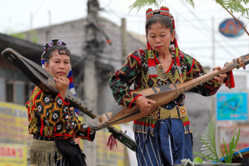
- T’boli Cultural Community
- Located at west of Lake Sebu
- T’bolis are famous for their colourful costumes, intricate beadwork, beautiful woven baskets and traditional brass ornaments
- The most famous T’boli product produced by the women dreamweavers of Lake Sebu is the T’nalak
- Land Dulay
- Most famous weaver of all who shares her skills with the younger generations
- Flom’lok Festival
- Celebrated from September 2nd to 16th to commemorate Polomolok’s foundation
- Flom’lok came from a B’laan word which means “hunting ground”
- Celebrated by the people of Polomolok by showcasing the local products and a mix of socio-cultural activities.
- Linggo ng Matutum
- Celebrated every March 13th to 20th of the year to celebrate the declaration of Mt. Matutum as a protected landscape
- Lemlunay Festival
- Also known as T’Boli Tribal Festival
- An annual celebration every third week of September staged at Lake Sebu
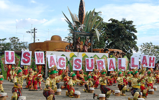
- Lembohung Festival
- It primarily showcases the rich and unique culture of the original inhabitants of Surallah which are the Tagabili tribe.
- Lembohung came from the T’boli words “Lem” which means within and “Bohung” which is a pineapple-like ornamental plant with white flowers in between its leaves
- T’nalak Festival
- An annual celebration that demonstrates the importance of T’nalak cloth as the cultural image of the South Cotabato
- Kulitangtang Festival
- Came from the word Kulitangtangan which is the ringing of a bell when there is a gathering
Geographical/Environmental Aspects
- Latitude: 6°15ˈN
- Longitude: 125° E
- Climate Type : IV
- Rainfall is more or less evenly distributed throughout the year
- Hottest period: January to April
- Coolest period: July to December
- Period with highest humidity : June to October (88% humidity recorded at Tupi seed farm)
- Period with lowest humidity: February and April (72% humidity recorded)
- Maximum daytime temperature: 36-38°C
- Nighttime temperature: 23-32°C
- Biggest municipality: Lake Sebu (Land area approximately 891.38 square kilometres)
- Smallest municipality: Sto. Niṅo (Land area approximately 109.04 square kilometres)
Politics
- Governor – Daisy Fuentes
- Vice Governor – Vicente De Jesus
- Representative
- 1st District – Pedro Acharon Jr.
- 2nd District – Ferdinand Hernandez
- Board Member
- 1st District – Eamon Gabriel Matti
- 2nd District – Ma. Ester Catorce
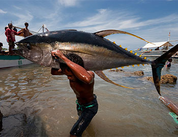
GENERAL SANTOS
- “Tuna Capital of the Philippines”
- Commonly called as GenSan
- With 26 Barangays
- Apopong
- Baluan
- Batomelong
- Buayan
- Bula
- Calumpang
- City Heights
- Conel
- Dadiangas East
- Dadiangas North
- Dadiangas South
- Dadiangas West
- Fatima
- Katangawan
- Labangal
- Lagao
- Ligaya
- Mabuhay
- Olympog
- San Isidro
- San Jose
- Siguel
- Sinawal
- Tambler
- Tinagacan
- Upper Labay
History/Trivias/Intro
- February 27, 1939
- 62 Christian settlers from Luzon were relocated to the shores of Sarangani Bay aboard the steam ship “Basilan” of Compania Maritima led by General Paulino Santos
- The relocation was organized under the National Land Settlement Administration (NLSA)
- The 62 Christian settlers who are mostly agricultural and trade graduates were the first big batch of settlers to land in GenSan with the mission to industriously cultivate the fertile expanse of land
- Thousands more from Luzon and Visayas migrated into GenSan which started the displacement of some native B’laan tribe to the mountains and lost their livelihood
- B’laan people were the original settlers of GenSan
- B’laan people were called Dadiangas during those times
- B’laans lived a nomadic way of life in and around GenSan
- In March 1939
- Alagao, the first formal settlement in GenSan, was established. It is now known as Barangay Lagao
- During then, it was known as the “Municipal District of Buayan” under the jurisdiction of the deputy governor of the Municipal District of Glan
- October 1, 1940
- Alagao became an independent Municipal District of Buayan
- Datu Sharif Zainal Abedin, an Arab mestizo who married a daughter of a very influential datu of lower Buayan, was appointed as the first district municipal mayor
- June 1954
- The Municipality of Buayan was renamed General Santos as a tribute to General Paulino Santos through Republic Act No. 1107 which was authored by Congressman Luminog Mangelen of Cotabato Province.
- Yellow Fin Tuna
- Known for the Tuna Capital of the Philippines for its abundance of the yellow fin tuna
Land Area
- 53 601 Hectares or 95 square miles
Population
- 538,086
Tourism
- Kaljala Karsts Eco-Tourism Park.
- It came from the word, Kalaha, which means frying pot because it looked like one due to the surrounding towers of karsts formation. It produced natural waterfalls and caves
- Kalaha”(“frying pot”) as it looked like one due to the surrounding towers of karsts formation naturally formed millions of years ago. It produced natural waterfalls and caves.
- Kalaja Cave
- A cave that has a pool inside which is about 3 meters deep and 22 meters wide
- Nopol Hills
- Amsikong Falls

Personalities
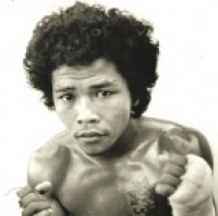
- Nonito Donaire
- Professional boxer

- Rolando Navarette
- Professional boxer
- Jinkee Pacquiao & Manny Pacquiao,
- Politicians
- Manny, professional boxer

- Bo Perasol
- Head coach of Ateneo De Manila Blue Eagles Basketball Team

- Shamcey Supsup
- Miss Universe 2011 Pageant 3rd Runner-up

Culture/Events
- The predominant religion is Christianity, comprising about 70% of the population. Some 8% belong to the Protestant churches and Iglesia ni Cristo. The remaining 22% belong mainly to the Islam community
- Tuna Festival
- Celebrated during September
- A thanksgiving festival for bounty of the sea especially the tunas. Various tuna cuisine and other culinary competitions are held
- Attractions are street dancing and fluvial parades

- Kalilangan
- Means festival, festivity or jubilation
- Celebrated every February
- A social gathering marked by exchanging of amenities amont traditional leaders, elders, allis and subodinates in varying tones
Geographical/Environmental Aspects
- Elevation: 14 meters
- Latitude: 06°07ˈN
- Longitude: 125°11ˈE
- Outside the typhoon belt
- Köppen Classification: Tropical Rainforest Climate
- Tropical rainforest climate is a type of tropical climate in which there is no dry season – all months have mean precipitation values of at least 60 mm (2.36 in). Tropical rainforest climates have no pronounced summer or winter; it is typically hot and wet throughout the year and rainfall is both heavy and frequent. One day in an equatorial climate can be very similar to the next, while the change in temperature between day and night may be larger than the average change in temperature between “summer” and “winter”.
- Average Annual Temperature: 28.3°C/83.0°F
- Warmest month: March (Average Temperature : 28.9°C/84.0°F)
- Coolest month: January (Average Temperature: 27.8°C/82.0°F)
- The highest recorded temperature is 42.8°C/109.0°F which was recorded in June.
- The lowest recorded temperature is 17.8°C/64.0°F which was recorded in May.
- Average Amount of Precipitation: 42.2 in/1071.9 mm.
- Month with most precipitation: June (Average Precipitation:4.8 in/121.9 mm)
- Month with the least precipitation: March (Average Precipitation: 1.6 in/4.6 mm)
Politics
- Mayor – Ronnel Rivera
- Vice Mayor – Shirlyn Bañas
- Councilors
- Beth Bagonoc
- Bobby Pacquaio
- Rosalita Nuñez
- Odjok Acharon
- Dominador Lagare Jr
- Jeng Gacal
- Shandee Lldo
- Jose Yumang
- Van-van Congson
- Lulu Casabuena
- Ramon Melliza
- Brix Tan
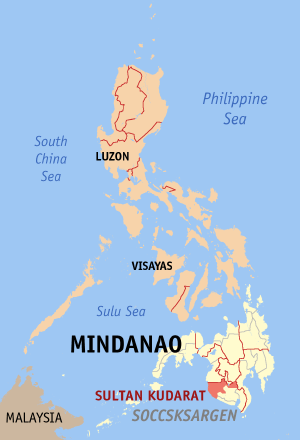
SULTAN KUDARAT
The name of the province was derived from a Muslim ruler, the late Sultan Mohammad Dipatuan Kudarat of the Sultanate of Maguindanao, who reigned from 1625 to 1671. He was a virtual leader who embodied the idea of basic unity, oneness and freedom among the diverse people scattered throughout his Sultanate. He was considered as one of the national heroes of the Republic of the Philippines not only because of his virtues of leadership but also because of his patriotic exploit in repelling Spanish domination. For his honor, Sultan Kudarat province was named after him.
Retrieved from http://tagalog.wikipilipinas.org/images/d/d7/Ph_locator_sultan_kudarat_isulan.png
For a more detailed map, click here (Google map).
History
Sultan Kudarat was made an independent province on November 22, 1973 by virtue of Presidential Decree No. 341.
Prior to this proclamation, Sultan Kudarat was part of the former Empire Province of Cotabato presently covered by three provinces namely: Sultan Kudarat, Maguindanao and Cotabato. Being one of the largest and the richest provinces in the country, there was a necessity to divide the former province of Cotabato into smaller units. Its potentials have not been fully developed due to the magnitude of the task of the provincial government. Besides, the trouble that have long plagued the area need to be resolved and many conflicting political, social and economic interest limited the progress of the province. There was an immediate need to promote stability and accelerate the development in the area. As a result of the division, Sultan Kudarat province came into existence.
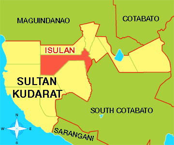
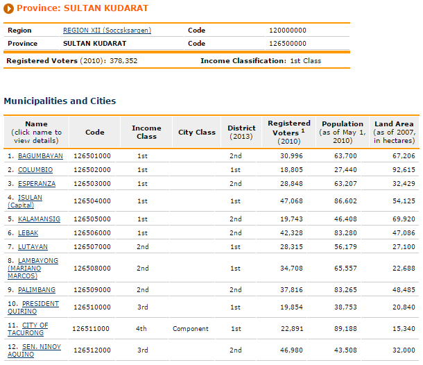
Sultan Kudarat is now under the administrative supervision of Region XII, per E.O. No. 36. It is composed of 11 municipalities and 1 component city namely; Bagumbayan, Columbio, Esperanza, Isulan, Kalamansig, Lebak, Lutayan, Lambayong, Palimbang, President Quirino, Senator Ninoy Aquino and Tacurong City. Isulan, the provincial capital is 88 kilometers from Cotabato City, 103 from General Santos City and 174 kilometers from Davao City.
Geography
- Location
Sultan Kudarat is located in the southwestern part of the island of Mindanao. It is bounded on the north by its sister provinces of Maguindanao and Cotabato; on the south by the provinces of South Cotabato and Sarangani; on the east by Davao del Sur; and on the west by Celebes Sea.
The municipality of Isulan is the capital town of the province which is approximately 88 kilometers from Cotabato City; 174 kilometers from Davao City and 103 kilometers from General Santos City.
The province is strategically located in the BIMP-EAGA region. Its coastal areas and towns are directly facing Australia and the three major ASEAN growth partners (Malaysia, Indonesia and Brunei), making it a potential backdoor of the Philippines to these countries.
The province is outside the typhoon belt as it lies on the region between latitude 6 and 7 degrees North and between longitude 124 and 126 degrees East.
Climate
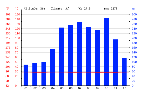
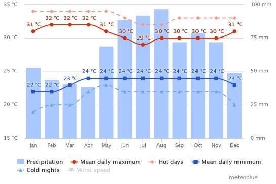
The climate is tropical in Sultan Kudarat. There is significant rainfall throughout the year in Sultan Kudarat. Even the driest month still has a lot of rainfall. The Köppen-Geiger climate classification is Af. The average annual temperature is 27.3 °C in Sultan Kudarat. The average annual rainfall is 2273 mm. In terms of Philippine climate system established by Coronas, Sultan Kudarat falls under the Type B of climate characterized by a short dry season of 1 to 3 months and with an average of 92.78 millimeters of rainfall every month. this provides sufficient soil moisture for its agricultural endeavors.
The province has an advantage over other provinces since it is free from typhoons and the rainfall is evenly distributed throughout the year.
Retrieved from http://images.climate-data.org/location/21205/climate-graph.png
The driest month is January. There is 88 mm of precipitation in January. Most precipitation falls in October, with an average of 283 mm.
Retrieved from http://images.climate-data.org/location/21205/temperature-graph.png
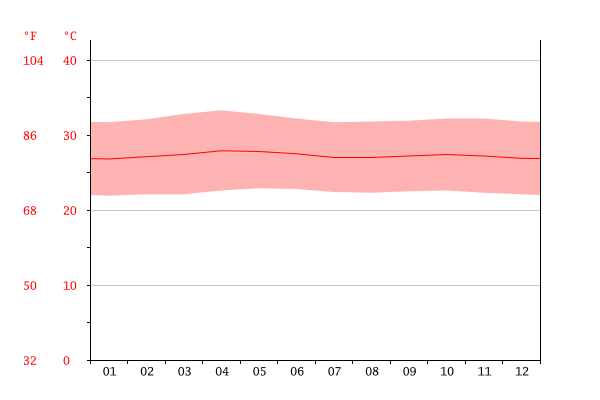
With an average of 27.9 °C, April is the warmest month. In January, the average temperature is 26.8 °C. It is the lowest average temperature of the whole year.
Population
The total population of the province is 747,087 as of 2010.
Retrieved from http://www.nscb.gov.ph/activestats/psgc/province.asp?provcode=126500000
Language
The 2000 census of population showed a total of 84 languages spoken in the province. The major languages are Hiligaynon (Ilonggo), Maguindanao, Ilocano, Cebuano, and Manobo.
Tourism
- Sultan Kudarat Provincial Capitol
- Standing right in the center of the Isulan is the Sultan Kudarat Provincial Capitol which gives you a glimpse of the Arabic architecture with its white Arabic-inspired structure noticeable for its a big gold dome at the center.
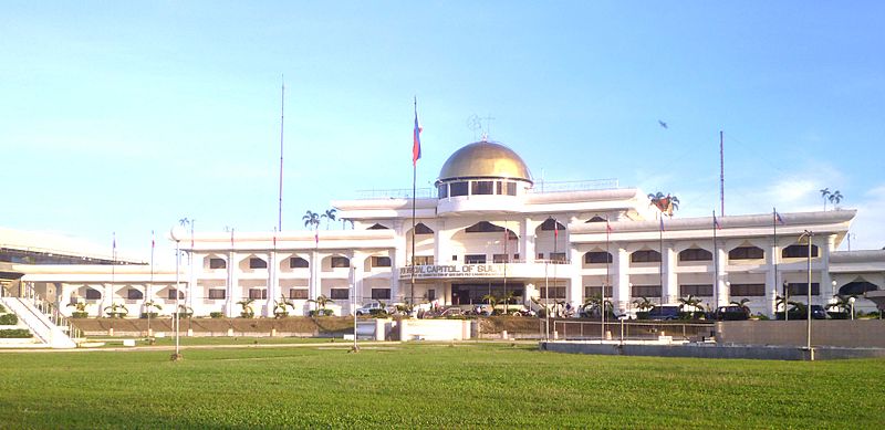
Retrieved from http://triptheislands.com/wp-content/uploads/2014/10/800px-Capitol-single.jpg
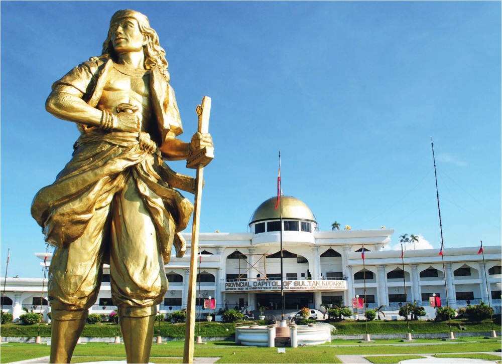
Retrieved from https://geekrepublik.files.wordpress.com/2015/08/sultan.jpg
- Balot Island
- A secret island complete with the ingredients for a perfect getaway, Balot Island is every sun worshippers’ paradise. It boasts of fresh sea breeze, calm turquoise waters, pristine white sand beaches, satisfying every real beach lover’s dream. Balot is one of the six islets in Barangay Paril, Kalamansig.
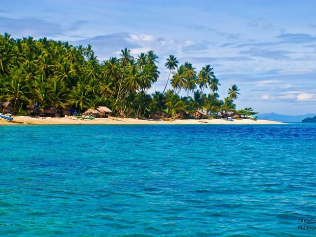
Retrieved from http://triptheislands.com/wp-content/uploads/2014/10/aw5zENx.jpg
- Kalamansig
- The town of Kalamansig itself is a worthy attraction. It is famous for its crystal clear beaches, including Lenek, Santiak, Tayandak and Poral, as well as special coves.
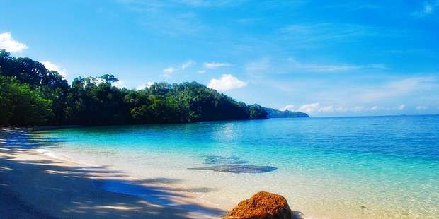
Retrieved from http://triptheislands.com/wp-content/uploads/2014/10/c150bb6a0243297dc5f6b644d8403cfd.jpg
- Tacurong
- The place to go for bird watchers, Tacurong is home to the Baras Bird Sanctuary. The sanctuary started with just 4 egrets in 1996, but now it has swelled to 20,000 and counting.
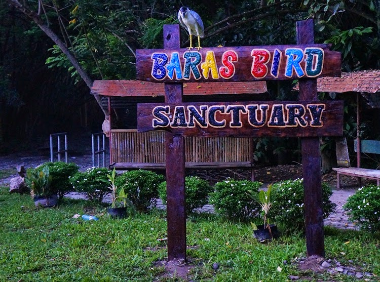
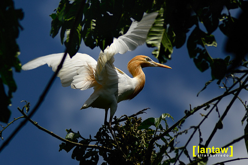
Retrieved from (1) http://3.bp.blogspot.com/-SwEviy6Bevw/VVDy8Us7aoI/AAAAAAAAZXk/jg7G-tIcJHA/s1600/baras%2Bbird%2Bsanctuary.JPG (2) http://farm9.staticflickr.com/8015/7226211050_dcfae63938.jpg
Other must-see attractions per town or city:
- Bagumbayan – Pitot Cave and Bamban Falls
- Columbio – Columbio Hot and Cold Spring, Sinapulan Cold Spring, Datablao Cave
- Esperanza – Mambucal Hot Spring
- Isulan – Lagandang Hot/Sulphur Spring
- Kalamansig – Sulfuric Hot Spring, White Sand Beaches, Burial Urns
- Lambayong – LAMRIS Dam
- Lebak – Nuling Hot Spring
- Lutayanl – Lake Buluan
- Palimbang – Alidama Island, Seven Lakes
- Senator Ninoy Aquino – Nati Spring, Kipulao Falls, Paradise Cave, Burial Urns
Natural Resources
- Land Classification
- Alienable & Disposable – 248,288 ha
- Public Land – 265,242 ha
- Land Use (SAFDZ)
- Forest Land – 258,433 ha
- Agricultural Land – 229,909 ha
- Non-Agricultural Land – 5,958 ha
- Fishing Ground – 12,421 ha
- Lakes & other bodies of water – 5,237 ha
- Fishponds – 1,572 ha
- Soil Types
- Sandy Loam
- Clay Loam
- Loamy Sand
- Silty Clay Loam
- Miscellaneous Land (Hydrosol, Peat soil, River wash, Soil Undifferentiated, Mountain Soil, Rivers and Lakes)
- Mineral resources are abundant in the province making it one of the potentials for investments in Southern Mindanao. Metallic minerals are found mostly in the mountainous areas of Isulan, Basgumbayan, Sen. Ninoy Aquino, Palimbang and Columbio. These minerals are copper, gold, chromium, zinc and silver. Bureau of Mines and Geology explorations proved that there are sizeable amount of copper deposits in Bagumbayan and Palimbang. Non-metallic minerals found in the province include clay, sulfur, limestone, phosphate, sand and gravel, marbleized stone.
- Guano Resources – The province has also guano deposits in several caves in the mountainous areas of Bagumbayan, Columbio, Sen. Ninoy Aquino, Kalimansig, Lebak and Esperanza.
Politics
Elected Officials (2010-2013)
- Governor: Suharto T. Mangudadatu
- Vice Governor: Ernesto F. Matias
- 1st District w/ Tacurong City: Rep. Raden C. Sakaluran
- 2nd District: Rep. Arnulfo F. Go
Religion
According to the 2000 Census, the dominant religion is Christianity, particularly Roman Catholicism, which spread after the Second World War. The four major religious groups in Sultan Kudarat are Roman Catholicism (43.99%), Islam (40.88), Evangelical (1.20%), and Iglesia Ni Cristo (2.26%). Roman Catholics in the province fall under the jurisdictions of the Roman Catholic Diocese of Kidapawan and Diocese of Marbel, suffragans of Archdiocese of Cotabato. Other Christian groups constitute most of the remainders such as the Seventh-day Adventists, United Church of Christ in the Philippines, Jehovah’s Witnesses, United Methodist Church, Southern Baptists, as well as “tribal religions”, among others.
Culture/Events
- Kalimudan Festival
Retrieved from http://doonposaamin.ph/events/kalimudan-festival-in-sultan-kudarat#photo
The Kalimudan Festival is an annual gathering of different tribal groups in the Province of Sultan Kudarat which aims to unite the different ethnic groups living in Sultan Kudarat, such as the Manobo, T’boli, Tiruray and so on. It comes from a Maguindanao term , which means an informal gathering. It highlights the richness of the cultures in Mindanao through various activities such as cultural presentations, sports fest and street dancing. The festival also celebrates the founding anniversary of Sultan Kudarat. The duration of the celebration usually begins in mid-October up until the end of the month of November.
(NORTH) COTABATO
Retrieved from http://cotabatoprov.gov.ph/wp-content/uploads/2013/07/mapa_640.png
For a more detailed map, click here (Google map).
The original Cotabato Province known as the Empire Province of Cotabato used to be the largest in the country in terms of land area. Its capital is Kidapawan City. Cotabato derives its name from the Maguindanao word kuta wato (from Malay – “Kota Batu”), meaning “stone fort”, referring to the stone fort which served as the seat of Sultan Muhammad Kudarat in what is now Cotabato City.
History
- September 1, 1914 (founded as the Empire Province of Cotabato)
- November 22, 1973 (Maguindanao and Sultan Kudarat were carved out)
The pace of settlement in the region accelerated in the 1950s and 1960s. The former province of Cotabato was once the largest in the Philippines. In 1966, South Cotabato was created as a separate province. In 1992, the province of Sarangani was formed out of South Cotabato. On November 22, 1973, through Presidential Decree No. 341, what remained of the old Cotabato was further divided into the provinces of North Cotabato, Maguindanao, and Sultan Kudarat. North Cotabato was later renamedCotabato through Batas Pambansa Blg. 660 approved on March 7, 1984.
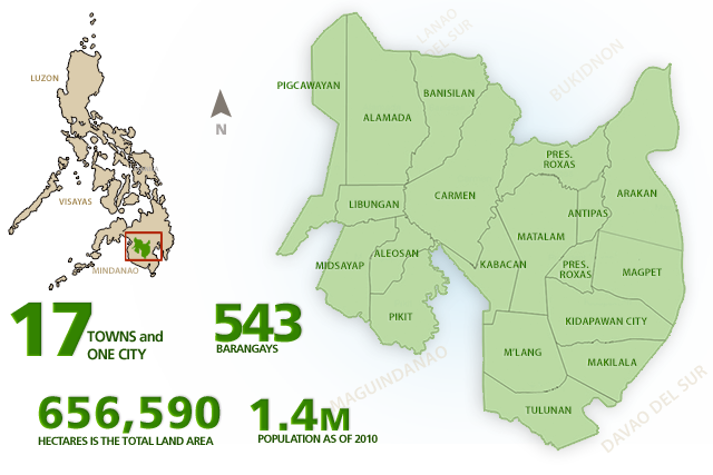
Cotabato now comprises the capital city of Kidapawan, 17 municipalities, and 543 barangays. The province currently has threecongressional districts.
Geography
- Location
The Province of (North) Cotabato lies on the eastern part of Region XII and is strategically located in the central part of Mindanao. It is bounded on the North by the Province of Bukidnon, on the northwest by Lanao del Sur, on the East by Davao City, on the Southeast by Davao del Sur, on the West by Maguindanao Province and on the southwest by Sultan Kudarat Province. Mountains to the east peak at Mount Apo, a volcanic cone that is the highest mountain in the Philippines. In the west, the Piapungan Range separates it from Lanao del Sur. The fertile Pulangi River basin runs in the middle of these two highlands and spreads towards the southwest to the flood plains of Maguindanao. Typhoons do not pass through (North) Cotabato and rainfall is evenly distributed through out the year.
- Land Area
The rich vast land resources of the Province stretch over an area of 656,590 hectares representing 36 percent of the regional land area (1,815,500 hectares). It ranks first in terms of land area among the four provinces of Region XII.The province of Cotabato is composed of seventeen (17) municipalities and one (1) city with five hundred forty three (543) legally created barangays, with Kidapawan City as its Capital.
- Soil Classification
There are about 19 types of soil found in the province of (North) Cotabato. Mountain soils, which are undifferentiated, are found at the eastern and western part of the province. Clay loam soil is found in the municipalities of Carmen, Tulunan, Pigcawayan and Pikit while the municipalities of Aleosan, Midsayap, Banisilan and part of Magpet, Pigcawayan and Pres. Roxas have a clay type soil. Sandy clay loam soils characterize those in the Municipalities of Makilala and Mlang and the City of Kidapawan.
The most prevalent soil types in the province are of clay loam type. These types are mostly found in the plains, which are best suited for intensive crops like corn, rice and other permanent crops.
- Geological Features
The predominant geological complex is the Cotabato Basin which empties into Illana Bay via Rio Grande de Mindanao into which flows most of its principal tributaries, namely: the Malasila and the Kabacan Rivers. The tributaries have carried silt for centuries from the mountain ranges of Bukidnon and the province, depositing these in the lowlands which resulted in the agricultural lands in the province.
- Soil Topography and Drainage Conditions
The province’s terrain varies from flat, fertile plains to irregular landscape of wide valleys, scattered hills and extensive mountain ranges such as the Kitubod Range, Mt. Apo which forms the natural boundary between (North) Cotabato Province and Davao City and Davao del Sur Province and the Tuael Range, which joins the municipalities of Pres. Roxas, Magpet and Matalam. A big portion of the land of North Cotabato province is classified as upland with a topography ranging from level to nearly level to gently sloping to undulating; undulating to rolling; rolling to moderately steep; steep to very steep. Areas with level to nearly level are found in Kabacan, Matalam, Libungan, Carmen, Pikit and parts of Tulunan, M’lang and Midsayap. The drainage condition in the province is generally poor with some portions classified as good to fair drainage. These conditions are mostly found along the plains and valleys. In the upland areas the drainage conditions range from good to fair to excessive erosion as a result of massive forest destruction.
Climate
The agro-climate of the whole province is characterized by a rainfall region wherein the wet and dry seasons are slightly pronounced. Rains may fall anytime during the year but normally from May to October. The rest of the year is a relatively dry season. Based on data, it was in CY 2003 that records the highest total monthly rainfall with 3,201.10 mm.
Population
The total population of the province is 1,226,508 as of as of May 1, 2010.
Retrieved from http://www.nscb.gov.ph/activestats/psgc/province.asp?provcode=124700000
Language
Languages mostly spoken are Hiligaynon, Cebuano, Maguindanao, Ilocano, Tagalog.
Tourism
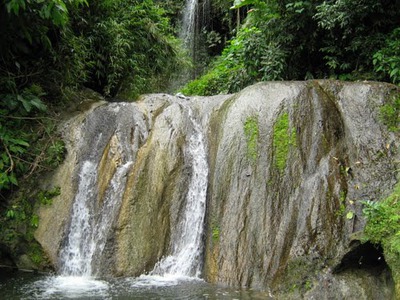
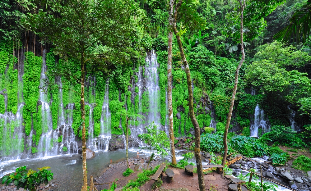
- Asik-Asik Falls
- The name comes from a Hiligaynon term, which means to sprinkle. It is located in the town of Alamada.
Retrieved from https://mountaingorillaboy.files.wordpress.com/2014/09/jbp4818.jpg
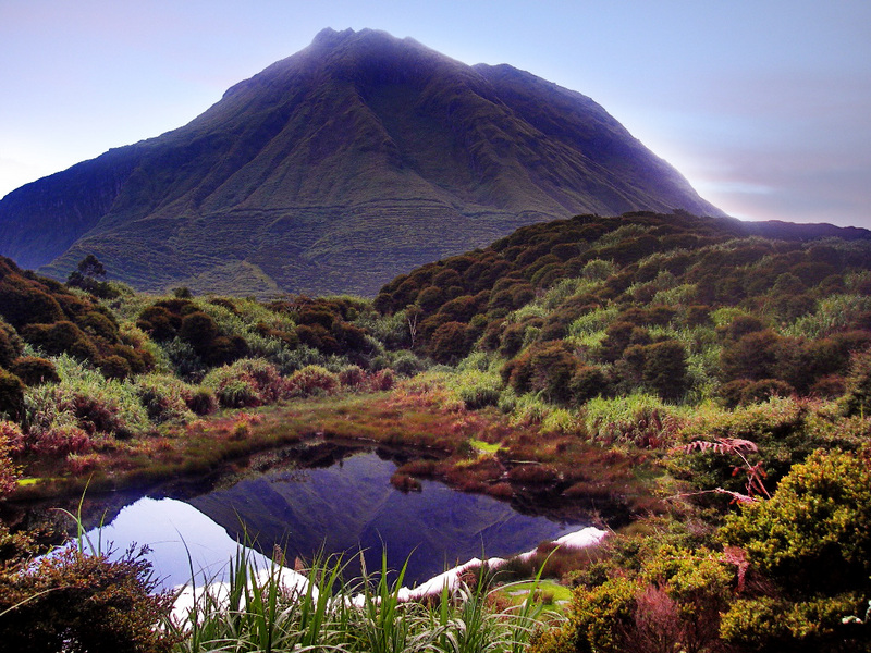
- Mt. Apo
- This mountain is the highest peak in the Philippines and also a home of the endangered Philippine Eagle, the country’s national bird. It is surrounded by moss-covered century-old trees, captivating flora and fauna, sulfur crater and massive boulders. It is one of the most popular summer destinations in Mindanao. Mt. Apo, with a total land area of 72,769 hectares of tropical rainforest, is declared natural park. It has an elevation of 2,956 meters above sea level.
- It is actually located between Davao City and Davao del Sur province in Region XI and Cotabato province in Region XII. The peak overlooks Davao City at 45 km (28 mi) to the northeast, Digos City at 25 km (16 mi) to the southeast, and Kidapawan City at 20 km (12 mi) to the west.
Retrieved from http://www.travelphilippinesnow.com/wp-content/uploads/Mount-Apo.jpg
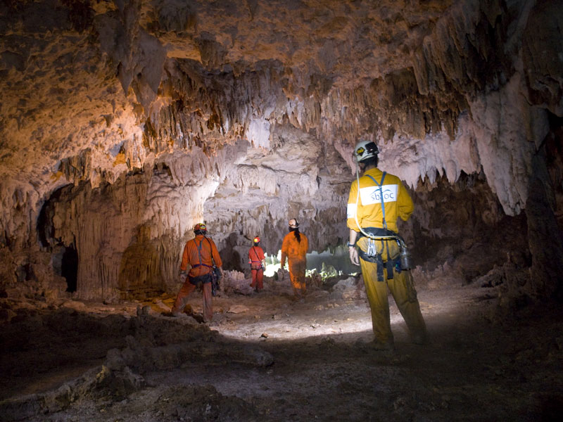
- Pisan Caves
- Located in Kabacan, North Cotabato, it is a natural underground cave with giant stalactites and stalagmites having a free-flowing natural swimming pool.
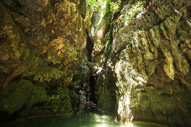
Retrieved from http://www.mindanews.com/wp-content/uploads/2014/01/28pisan05e.jpg
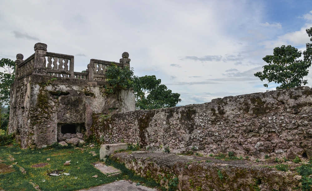
- Fort Pikit
- Built in 1893 of stone masonry as part of the series of military fortification in Mindanao by the Spanish colonial government, it is truly a historical landscape. It was used by the American colonial government in 1902 and in 1912-1945. It was occupied by the Japanese Imperial Army and recovered by the American forces in their advancement to liberate Eastern Mindanao during the World War II.
- The National Historical Commission of the Philippine had declared Fort Pikit as a National Historical Landmark in March 2012.
Retrieved from http://cms.interaksyon.com/lifestyle/assets/2013/08/6_cotprov_fortpikit.jpg
Natural Resources
- Mineral Resources
Mineral products found in the province consist of non-metallic products defined as limestone, sand and gravel, soil and white clay. The first three items are considered as construction materials while the white clay is a good raw material for porcelain production and considered as one of the best white clay resource in the country. It is abundant in the municipalities of Banisilan, Pres. Roxas, Mlang, Makilala and Magpet particularly in the barangays of Dolis, Inac and Nowa.
The province has several ceramics processing which are either unregistered or registered enterprises. Magpet Ceramics located at Magpet, Cotabato is an LGU-managed enterprise that specializes in the making of pots and jars, table wares, novelties and art wares.
- Aquatic Resources
The province is traversed with several rivers and creeks, which abound with freshwater fish. Many people depend much on freshwater fishing especially those in the vicinities of Liguasan Marsh and Libungan Marsh.
- Power Resources
The major power source of the Mindanao Grid is the Lanao Lake-Agus River hydro-electric power complex with a total power potential of 1,000 megawatts. Supplementing the hydro-potential power of the Mindanao Grid are the Cotabato and Agusan River Basin. The basins have potential of 1,605 megawatts and 991 megawatts, respectively or an aggregate total of 2,596 megawatts.
In support to the province’s growing economy, the Philippine National Oil Company (PNOC) has commissioned the generation of at least 52-megawatt sourced out from the Mt. Apo Geothermal Project. An additional capacity of 50 megawatt from the project is currently worked-out to ensure a stable energy supply for the province and its neighboring areas.
Politics
Elected provincial officials
- House of Representatives
- 1st District — Rep. Susing Sacdalan
- 2nd District — Rep. Nancy Catamco
- 3rd District — Rep. Jose Pingping I. Tejada
- Governor: Emmylou Taliño-Mendoza
- Vice Governor: Dodong Ipong
Religion
Contrary to the belief of some Filipinos, Cotabato is actually a predominantly Roman Catholic province with 49.56% adherence (due to many decades of immigration from Luzon and Visayas) while Islam is 46.23%. The minority remainders are divided among some Protestant Christians.
Culture/Events
- HALAD SA STO. NINO FESTIVAL – held every third Sunday of January in the Municipality of Midsayap, celebrated in honor of the town’s patron saint Sr. Sto. Nino, highlighted by the colorful street dancing and parade competition.
- KASADYAHAN FESTIVAL – is celebrated every 6th of April in the Municipality of Aleosan. This festival comprises different activities like street dancing, Lechon Manok parade and trade fair.
- TIMPUPO FESTIVAL – is an annual celebration in the City of Kidapawan, People in the place bring variety of fruits to the streets. Cultural shows, parade of local fruit products, exhibits, and street dancing competition are only some of the activities held in this fruit festival.
- KAPAGAYAN FESTIVAL – is celebrated by KabaKenos every 18th of August as a way of thanksgiving for the abundant harvest of palay, the town’s major crop.
- TAHITI FESTIVAL (August 13) – an annual celebration of the vast production of soft brooms and handicrafts making use of tahitl grass which become the main product of the Manobos in the Municipality of Magpet.
- DINORADO FESTIVAL (August 30) – a boisterous merry-making of abundant harvest of dmorado rice celebrated during the annual foundation anniversary of the Municipality of Arakan.
- SINAB’BDAN FESTIVAL (October 10) – is a festivity celebrating the oneness and unity of the tri-people of the Municipality of Makilala.
- KAHIWATAN FESTIVAL (October 20) – ‘hiwat’ derived from llonggo term which means activities. It is a festival commemorating the anniversary of Pigcawayan.
- KAWAYANAN FESTIVAL – is celebrated during the first week of December in the Municipality of M’lang featuring the municipal thanksgiving day, lechon sa kawayan contest, bamboo showcase, cultural show and various sports events.
- KADAGAYAAN FESTIVAL (December 8) – derived from an Ilonggo term “dagaya” which means abundance, the festival is a presentation of the people’s pride being the major producer of agricultural products in the Municipality of Alamada.
- KANYONG KAWAYAN FESTIVAL (December 22) – an activity that advocates against the use of pyro-technics,during tho yuletide season. It is a citywide contest in Kidapawan that features the firing of bamboo canons using empty milk can projectiles.
References:
Featured image: https://upload.wikimedia.org/wikipedia/commons/3/33/Ph_locator_region_12.png
- http://www.nnc.gov.ph/regional-offices/region-xii-soccsksargen/region-12-profile/320-region-xii-soccsksargen
- http://www.nscb.gov.ph/activestats/psgc/regview.asp?region=12
- http://www.tourism.gov.ph/SitePages/InteractiveSitesPage.aspx?siteID=64
- http://region12.nia.gov.ph/profile_maps.html
- http://doonposaamin.ph/articles/places-to-go/6-things-about-the-astounding-asik-asik-falls-of-cotabato
- http://rparn.blogspot.com/2015/01/caving-in-pisan-cave-kabacan-cotabato.html
- http://www.mindanews.com/travel-lifestyle/2014/01/28/discovering-pisans-hidden-wonders/
- “Republic Act No. 4849 – An Act Creating the Province of South Cotabato”. Chan Robles Virtual Law Library. 18 July 1966. Retrieved 27 April 2016.
- Burgonio, TJ (15 September 2012). “Aquino signs law reapportioning Cotabato into 3 districts”. Philippine Daily Inquirer.
- http://www.tourism.gov.ph/SitePages/InteractiveSitesPage.aspx?siteID=66
- http://www.nscb.gov.ph/ru12/OVERVIEW/Sul_Kudarat.htm
- http://sultankudaratprovince.gov.ph/category/general-information/
- http://en.climate-data.org/location/21205/
- http://www.visitmyphilippines.com/index.php?title=SultanKudarat&Page=1&pid=1144
- http://triptheislands.com/contests/must-see-tourist-spots-in-sultan-kudarat/
- Socio-Economic Profile of Sultan-Kudarat 2010, p. 8.
- Socio-Economic Profile of Sultan-Kudarat 2010, pp. 10-11.
- http://doonposaamin.ph/events/kalimudan-festival-in-sultan-kudarat#photo
