
Cruzit, Carlos
Espina, Julienne Marie B.
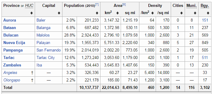
According to the National Economic and Development Authority (NEDA), Central Luzon is a sustainable and caring getaway. It is a region in the island of Luzon covering a total land area of 2,201,463 hectares. It comprises of seven provinces richly endowed with natural and human resources, namely: Aurora, Bataan, Bulacan, Nueva Ecija, Pampanga, Tarlac, and Zambales. It is the home of several special economic zones as it is strategically located at the heart of Asia, accessible through Clark and Subic, two of the country’s leading international gateways. It has globally competitive enterprises given the low cost of doing business and the critical mass of transport infrastructure.
The Department of Environment and Natural Resources describes Central Luzon as a combination of towering mountains, extinct and active volcanoes, lush, verdant farmlands, and natural sea harbors. It is one of the leading growth regions in the Philippines, strategically located at the heart of Asia. Region III lies between Manila and Northern Luzon. It is composed of seven provinces, twelve cities and 118 municipalities. Its 7 provinces are Aurora, Bataan, Bulacan, Nueva Ecija, Pampanga, Tarlac and Zambales. Its 12 cities are Balanga from Bataan, Malolos and San Jose del Monte from Bulacan, Cabanatuan, Gapan, Muñoz, Palayan and San Jose from Nueva Ecija; Angeles and San Fernando from Pampanga, Tarlac from Tarlac; and Olongapo from Zambales.
It includes all land area north of Manila Bay from the tip of Bataan peninsula on the west, and all the lands north of the Caraballo mountains on the east. It is the longest contiguous area of lowlands, and is otherwise known as the Central Plains of Luzon. The region produces one third of the country’s total rice production, thus is also called the Rice Granary of the Philippines.
The region has a dry season which is from November to May. Rains normally occur during the months of July to October.
Located adjacent to the National Capital Region (NCR), it has benefited from the “spillover” from Metro Manila. It is a part of the National Industrial Core Region, together with NCR and Region IV or the Southern Tagalog Region. The Core Region contributed 70% of manufacturing value added in 1988. It has emerged as an alternative area for investment to Region IV, but is still overcoming the effects of the Mount Pinatubo eruption in 1991.
Only 66 kilometers away from Metro Manila, Central Luzon contains the largest plain in the country and is the gateway to the Northern Luzon regions. It covers a total land area of 21,470 square kilometers. The City of San Fernando, in Pampanga, is the regional center. Aurora was transferred from Region IV to Region III through Executive Order No. 103 in 2002.


Tourism map (http://itsmorefuninthephilippines.com/wp-content/uploads/2013/03/GatewayRegion3.jpg)
OPPORTUNITIES & THREATS
- On food production capacity: http://www.centralluzondaily.net/major-problem/
- On disaster risk management: http://www.rappler.com/move-ph/issues/disasters/85902-preparing-disasters-central-luzon-pampanga
- On being a rising investment destination: http://manilastandardtoday.com/real-estate/99387/central-luzon-a-rising-investment-destination.html
http://manilastandardtoday.com/real-estate/99387/central-luzon-a-rising-investment-destination.html - On mining in Zambales: http://www.manilatimes.net/zambales-mining-conflict-worsens/251592/
- On wastes in Tarlac: http://www.philstar.com/nation/2015/08/15/1488088/canada-wastes-stuck-tarlac-landfill
- On environmental problems in Pampanga: http://angelescity.com/news/view/284
- On garbage in Pampanga: http://angelescity.com/news/view/727http://angelescity.com/news/view/727

Zambales
Known as the Chromite Capital of the Philippines, its history unfolds in 1572 when the famous Spanish conquistador Juan de Salcedo responded to the proposed invitation of the people from the undulating mountain ranges, then still thick with vegetation, which knifed across the vast lap of virgin land. The earliest towns established in 1607, 1611, and 1612 were Masinloc, Iba, and Sta. Cruz, respectively. Masinloc was the first capital of the province. At various points in history, the capital shifted from each of the three towns earlier named. Iba, however, in view of its strategic location, finally became the permanent seat of the provincial government.
Zambales, which covers an area of 361,110 hectares, shares common boundaries with Pangasinan in the North, Tarlac and Pampanga in the East and Bataan in the South. The entire stretch of the province in the West is rimmed by the crystal-clear waters of vast China Sea. The 13 sprawling towns dolting the province from the North to South, most of them along the shoreline are : Sta. Cruz, Candelaria, Masinloc, Palauig, Iba, Botolan, Cabangan, San Felipe, San Narciso, San Antonio, San Marcelino, Castillejos and Subic. Olongapo, until it became a chartered City, was the 14th town.
The name Zambales or the Hispanized term for Zambal, is derived from the spoken dialect and the ethnic site of the early Malay inhabitants of the place. It is alleged that the term was given currency on account of the fact that the Spanish conquistadors found these people highly superstitious who worship the spirits of their departed ancestors (Anitos), Now, the closer equivalent of the word worship is Sambal in the dialect hence the term Zambales.
The province is historical. Located here is the ancestral house of former Philippine President, Ramon Magsaysay, situated at Castillejos. Mt. Pinatubo, world-famous for its 1991 catastrophic eruption, can be found in the vicinity.
source: zambalesnow.com
GEOGRAPHY
Zambales lies on the western shores of Luzon island along the South China Sea. Its shoreline is rugged and features many coves and inlets. The Zambales Mountains in the eastern part of the province occupies about 60% of the total land area of Zambales. Subic Bay, at the southern end of the province, provides a natural harbor, and was the location of the U.S. Naval Base Subic Bay until its closure in 1992.
ADMINISTRATIVE DIVISIONS
Sangguniang Panlalawigan
- Governor Hermogenes Ebdane (Sulong Zambales Party)
- Vice Governor Ramon G. Lacbain II (Sulong Zambales Party)
District I
Olongapo City, Castillejos, San Marcelino, & Subic
District II
Botolan, Cabangan, Candelaria, Iba, Masinloc, Palauig, San Antonio, San Felipe, San Narciso & Sta. Cruz
No. of City 1
No. of Municipalities 13
No. of Barangays 230
Languages/Dialects Zambal, Ilocano, Tagalog
source: https://en.wikipedia.org/wiki/Zambales
DEMOGRAPHICS
source: psa.gov.ph
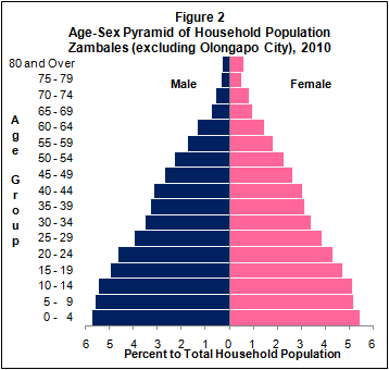
Population of Zambales (excluding Olongapo City) increased at the rate of 2.11 percent annually
Based on the 2010 Census of Population and Housing (CPH), the province of Zambales, excluding Olongapo City, posted a total population of 534,443 persons as of May 1, 2010. This is larger by 100,901 persons compared to its total population of 433,542 persons counted in the 2000 CPH. The increase in the population count from 2000 to 2010 translated to an average annual population growth rate (PGR) of 2.11 percent. This is higher than the 1.61 percent annual PGR of the province between the census years 1990 and 2000.

ECONOMY
Zambales is basically an agricultural province. The chief products are rice, corn, vegetables, and rootcrops. Major industries include farming, fishing, and mining.
The Olongapo area, once the site of the biggest U.S. naval base in Asia, is fast developing into an industrial and tourism zone under the Subic Bay Metropolitan Authority.
Zambales has been gifted with the natural beauty of its surroundings. It has been touched by civilization yet has maintained its rustic glory and beauty. The Zambales coastline is most famous for its sandy beaches and deep blue sea teeming with coral reefs.
TOURISM
disclaimer: we do not own any of these photos. credits to the owners
source: Google Images


Tarlac
Tarlac is known as the Melting Pot of Central Luzon. Tarlac is the most multicultural of the Central Luzon provinces. A mixture of four district groups, the Pampangos, Ilocanos, Pangasinenses, and Tagalogs, share life in the province.
Tarlac is best known for its fine foods and vast sugar and rice plantations. That it has fine cooking to offer is due largely to the fact that it is the melting pot of Central Luzon. It offers some of the best cuisines from the places of ancestry of its settlers, the provinces of Bulacan, Nueva Ecija, Zambales, Pangasinan, and the Ilocos Region.
Historical sites, fine food, vast plantations, a beautifully landscaped golf course, and so many other attractions – all these make the province of Tarlac one of the best of the places to visit in Central Luzon.
source: tourism.gov.ph
Tarlac’s name is a Hispanized derivation from a talahib weed called Matatarlak. Tarlac was originally a part of the provinces of Pampanga and Pangasinan. It was the last province in Central Luzon to be organized under the Spanish administration in 1874.
During the Philippine Revolution of 1896, Tarlac was among the first eight provinces to rise against Spain. It became the new seat of the first Philippine Republic in March 1899 when General Emilio Aguinaldo abandoned the former capital, Malolos, Bulacan. This lasted only for a month before the seat was moved to Nueva Ecija in Aguinaldo’s attempt to elude the pursuing Americans.
On October 23, 1899, Gregorio Aglipay, military vicar general of the revolutionary forces, called the Filipino clergy to a conference in Paniqui. There, they drafted the constitution of the Philippine Independent Church. They called for the Filipinization of the clergy, which eventually led to a separation from the Roman Catholic Church in the Philippines.
Tarlac was captured by American forces on November 1899. A civil government was established in the province in 1901.
source: https://en.wikipedia.org/wiki/Tarlac
GEOGRAPHY
The landlocked province is situated at the center of the central plains of Luzon, landlocked by four provinces: Pampanga on the south, Nueva Ecija on the east, Pangasinan on the north, and Zambales on the west. Approximately 75% of the province is plains while the rest is hilly to mountainous.
Eastern Tarlac is a plain, while Western Tarlac is hilly to mountainous. Because of this, the province includes a large portion of mountains like Mt. Telakawa (Straw Hat Mountain), located at Capas, Tarlac. Mt. Bueno, Mt. Mor-Asia and Mt. Canouman are located also in Capas as well as Mt. Dalin. The other mountains are Mt. Dueg and Mt. Maasin, found in the municipality of San Clemente. Also noted are Mt. Damas of Camiling. The whole of Mayantoc and San Jose are mountainous so it is suitable for the highest natural resources and forest products in the province such as coal, iron, copper, vegetables, fruits, log fires, sand, rocks and forest animals such as wild boar and deer. The main water sources for agriculture include the Tarlac River at Tarlac City, the Lucong and Parua rivers in Concepcion, Sacobia Bamban River in Bamban and the Rio Chico in La Paz.
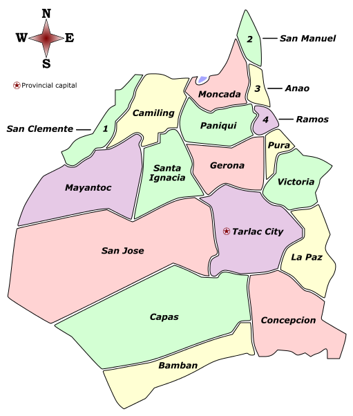
ADMINISTRATIVE DIVISIONS
Tarlac is subdivided into 17 municipalities and 1 component city, all encompassed by three congressional districts. There are a total of 511 barangays comprising the province.
- Governor Victor A. Yap (NPC)
- Vice Governor Enrique Cojuangco, Jr. (NPC)
DEMOGRAPHICS
Tarlac had a total population of 1,243,449 persons as of August 1, 2007, higher by 16.3 percent compared with the census count of 1,068,783 persons as of May 1, 2000. This increase translated to an annual population growth rate of 2.11 percent during the period 2000 to 2007.
Similarly, the household population of Tarlac increased by 16.3 percent from 1,067,996 persons in 2000 to 1,241,913 persons in 2007. The number of households, meanwhile, grew by 19.4 percent from 215,395 in 2000 to 257,249 in 2007. The average household size in 2007 was 4.8 persons, lower than the average household size of 5.0 persons in 2000.
ECONOMY
Principal crops are rice and sugarcane. Other major crops are corn and coconut; vegetables such as eggplant, garlic, and onion; and fruit trees like mango, banana, and calamansi.
Because the province is landlocked, its fish production is limited to several fishponds. On the boundary with Zambales in the west, forestlands provide timber for the logging industry. Mineral reserves such as manganese and iron can also be found along the western section.
Tarlac has its own rice and corn mills as well as sawmills and logging outfits. It has three sugar centrals. Other firms service agricultural needs such as fertilizer. Among its cottage industries, ceramics making has become important because of the abundant supply of clay.
source: tourism.gov.ph
TOURISM
disclaimer: we do not own any of these photos. credits to the owners
source: Google Images


Pampanga
Pampanga is known as the Culinary Center of the Philippines.
The name “Pampanga” comes from the word pangpang meaning riverbank, a fitting name for a flat country crisscrossed by a hundred small branches of the Pampanga River. The province lies in the southern portion of the central plains of Luzon. It is bounded on the east and southeast by Bulacan, on the north by Tarlac and Nueva Ecija, on the west by Zambales and on the southwest by Bataan. Towards the south, Pampanga opens up to Manila Bay. The terrain is flat except for some hills in the northwest, which form part of the Zambales Range, and for Mount Arayat in the northeast while along the bay are extensive swamplands. The climate is very distinct with the rainy season from May to October and the dry season from November to April.
It has been popularly believed and theorized that the Kampampangans, linguistically distinct from the Tagalogs who surround them, are descended from migrants from the Malang Region in Central Java sometime in the distant past. Whether or not they did come from Java, thriving settlements existed along the marshy banks of the coast and the rivers when Spanish conquistadors came in 1571.
When the Spaniards did come in that year, the Pampangans initially refused to submit to the conquerors and chose to resist them. Martin de Goiti was sent to reduce the recalcitrant people of Pampanga. After conquest was finally achieved, the province of Pampanga was established shortly thereafter. Originally, Pampanga comprised the whole of the Central Luzon region. The subsequent creation of other provinces like Bataan, Nueva Ecija, and Tarlac, reduced the size of the province.
During the Spanish period, Pampanga was an important source of food, forced labor and lumber for the Spanish colony. Rice, which was produced in great abundance, was levied as tribute. In the 17th century, there were two great disturbances that rocked the province. In 1645, Francisco Maniago led a revolt against the tribute payments being exacted by the colonial officials. In 1660, the forces of Melchor de Vera, under the orders of Andres Malong of Pangasinan, tried to incorporate Pampanga into a Pangasinan-based kingdom but were thwarted at Magalang. Pampanga was one of the first provinces to join the revolution of 1896 and San Fernando served as a temporary capital of the Philippine Republic in 1899.
During the American period, Clark Air Base, one of the largest bases outside continental United States, was erected in northern Pampanga. This base provided the United States an important front position in East Asia and even after Philippine independence in 1946, it was retained because of its strategic importance.
In the 1940s and 1950s, the province was a hotbed of the armed socialist movement called the Hukbalahaps. The movement fed on agrarian problems resulting from the concentration of land in the hands of a few families. To address this problem, the national government embarked on an agrarian reform program, which was implemented during the time of President Diosdado Macapagal, a Pampango. The province was one of the earliest areas placed under agrarian reform.
In 1991, Mount Pinatubo erupted causing widespread destruction in northwestern Pampanga and continued threats by destructive lahar flows on low-lying towns. The Clark Air Base was abandoned by the United States as a result of the eruption. The biggest single project, the Mega Dike, was erected in Pampanga to contain the lahar and save the towns of the province. Clark Air Base, on the other hand, was rehabilitated and was converted into a special economic zone.
source: http://www.islandsaccommodations.com/places/pampanga.htm
GEOGRAPHY
The province has a total land mass of 206,247 hectares (509,650 acres). Its terrain is relatively flat with one distinct mountain, Mount Arayat and the notable Pampanga River. Among its municipalities, Porac has the largest land mass with 314 square kilometres (121 sq mi); Candaba comes in second with 176 square kilometres (68 sq mi); followed by Floridablanca with 175 square kilometres (68 sq mi). Santo Tomas, with an area of 21 square kilometres (8.1 sq mi), is the smallest.
source: https://en.wikipedia.org/wiki/Pampanga
The province of Pampanga is a part of the great plain extending from Manila Bay north of the gulf of Lingayen, Pangasinan. Most of this area is only a few meters above sea level. Mt. Arayat, with a height of 3,200 ft. and the elevated strip along the western boundary of the Zambales Mountain rise to a height of nearly 1,900 meters constitute the only highland. The general slope is south and southeast towards Manila Bay and Rio Grande. In the northwestern part of the province, however, the land slope is going downward towards Mt. Arayat. Not far from the base is the Pampanga River which channels floodwaters into the wide Candaba Swamp, then to tributaries, rivulets, creeks and finally to Manila Bay.
source: http://www.pampanga.gov.ph/index.php/general-information/physical-profile.html
ADMINISTRATIVE DIVISIONS
Pampanga comprises 19 municipalities and three cities (one highly urbanized and two component).
- Governor Lilia G. Pineda (NUP/KAMBILAN)
- Vice Governor Dennis “Delta” G. Pineda (NPC/KAMBILAN)
source: https://en.wikipedia.org/wiki/Pampanga
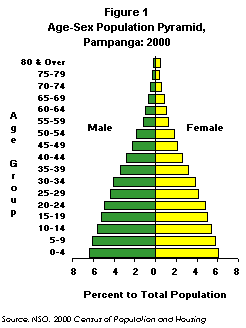
DEMOGRAPHICS
source: psa.gov.ph
Population to double in 23 years
Pampanga registered a total population of 1,614,942 persons. This was up by 213,186 persons as compared to the figure recorded in the 1995 Census of Population.
The highest annual population growth rate recorded for Pampanga since 1903 was during the intercensal period 1960 to 1970 at an annual population growth rate of 3.54 percent, slightly higher than the annual population growth rate recorded during the 1995 to 2000 period (3.08 percent). If the current growth rate continues, the population of Pampanga was expected to reach three million in 23 years.
In 2000, the number of households was 307,639 with an average household size of 5.25 persons, higher than the national average of five persons.
ECONOMY
Pampanga is taking center stage as the country shifts into industrial high gear. With 2,181 square kilometers of mostly rich arable land, the province has always been a net exporter of food products like rice, sugar, vegetables and fruits as well as poultry, livestock and inland fish products. It is also richly blessed with a highly skilled and highly educated resource pool of manpower, with a population (1995) of 1,500,000 who have a tradition of industrial pursuit especially in the fields of woodcraft, food processing, ceramics, metalworking and decorative crafts.
An excellent network of good roads covers the entire province and connects to the main arterial highway to Manila and Olongapo City. An international airport is located within the Clark Special Economic Zone, while other utilities such as power, telecommunications and potable and irrigated water extensively cover the entire province and are readily available for industries and businesses.
Tourism is also fast becoming a major industry in Pampanga. The province is a convenient center to explore and enjoy the entire Central Luzon region. Clark is focal to this developing sector, with the operation of first rate hotels, resorts, gaming establishments and golf courses. Further investments in tourism-related activities and support services are necessary to meet the ever-increasing demands of local and foreign tourists.
source: http://www.islandsaccommodations.com/places/pampanga.htm
TOURISM
disclaimer: we do not own any of these photos. credits to the owners
source: Google Images


Bataan
According to a historian, Bataan was established in January 11, 1757 by Governor-General Pedro Manuel Arandia out of territories belonging to Pampanga and the corregimiento of Mariveles, which includes Maragondon, Cavite across the Manila Bay.
But this province featured prominently during World War II. Shortly after the Japanese Army invaded the country in December 1941, the combined US and Filipino forces were being gradually overrun and General Douglas MacArthur moved his troops to the Bataan Peninsula in an attempt to hold out until a relief force could be sent from the US. Japanese forces started a siege of the peninsula on January 7, 1942, and launched an all-out assault on April 3, a few months after the Battle of the Points.
The majority of the American and Filipino forces surrendered on April 9 and were forced to march more than a 100 kilometres (62 mi) from Bataan to Capas-Tarlac, which became known as the Bataan Death March.
source: https://en.wikipedia.org/wiki/Pampanga
GEOGRAPHY
Bataan is the peninsula in the western part of Luzon that shields the Manila Bay on its south and east from the South China Sea on its west. Zambales and Pampanga form its boundaries on the north
source : http://www.visitmyphilippines.com/index.php?title=Profile%20of%20Bataan&func=all&pid=5698&tbl=0
ADMINISTRATIVE DIVISIONS
Bataan is subdivided into 11 municipalities and 1 component city, all encompassed by 2 congressional districts. There are a total of 237 barangays comprising the province.
- Governor: Albert S. Garcia (NUP)
- Vice Governor: Efren Dominic E. Pascual Jr. (LP)
source: https://en.wikipedia.org/wiki/Bataan
DEMOGRAPHICS
The population of Bataan was 662,153 persons as of August 1, 2007, based on the 2007 Census of Population (POPCEN 2007). This figure is higher by 104,494 persons over the population count of 557,659 persons in 2000. The population counts for the province from the 2000 and 2007 censuses translated to an average annual population growth rate of 2.4 percent for the period 2000 to 2007.
The number of households reached 139,125, which is 25,541 households more than the number in 2000. The average household size in 2007 was 4.7 persons, which is slightly lower than the average household size of 4.9 persons in 2000.
source: http://www.census.gov.ph/content/total-population-bataan-reached-662153-persond-results-2007-census-population
ECONOMY
Bataan is one of the most progressive provinces in Central Luzon and Manila Bay Region. The province plays a significant role in the region because it is strategically located right in the middle of the country’s growth triad corridor of SBMA, Clark Special Economic Zone and Metro Manila. It plays a major role in the Central Luzon “W” Growth Corridor, as the region’s industrial heartland owing to the presence of anchor industries within the Province. It is also a strategic transport route and transshipment point linking SBMA area and other Central Luzon provinces to Metro Manila. In addition, the province is a key contributor to the overall economic productivity in Central Luzon.
The province was identified as one of the country’s investment destinations. Moreover, the inclusion of Bataan in the Global Gateways, which is the centerpiece of development of the national government, will certainly spur the economic growth of the province. It promises to be the country’s next economic hub when the Subic-Clark-Tarlac Expressway Project (SCTEP) is finally put into place. This expressway will pass through Hermosa and Dinalupihan. It is complemented by the development of Subic Seaport and the Diosdado Macapagal Airport in Clark, Pampanga.
Pristine beaches and natural parks complemented by scenic springs and waterfalls as well as historical markers also provide a setting for a healthy tourism investment in the province.
The competitive market value, abundance of skilled workers and the availability of more lands and port areas make Bataan an attractive site for economic zones in the country. Presence of economic zones ensures that the province lives up to the expectations of all its investors as a primary investment capital of the country. The first economic zone in the country was put up in Mariveles in 1972.
source: http://www.bataan.gov.ph/home/about-bataan/economic-significance.html
Nueva Ecija
Successive evangelical missions and military expeditions shaped the founding of Nueva Ecija and its development as a province during the Spanish settlement in Central Luzon from late 16th century to the early decades of the 17th century.
Governor-General Fausto Cruzat Y Gongora established a commandancia or an advanced military outpost to protect the flourishing missions in Upper Pampanga in1705. He named it Nueva Ecija after his homeland in Ecija, Seville, Southern Spain, since both were washed by navigable rivers. The commandancia was raised to the status of regular province and was separated from Pampanga in 1848. Since then, the new province underwent gradual territorial changes. Many founded sitios became cabeceras that covered vast territorial jurisdiction. Later, towns or pueblos were established due to growing population brought about by migration and continuous pursuit for productive agricultural land.
When General Basco Y Vargas declared some areas in Luzon in 1782 for large-scale tobacco production under government control, Nueva Ecija drastically changed its agricultural activity from rice farming to tobacco growing. Its adverse effect and people’s dreadful experiences from the oppressive and repressive regime inflamed the hearts of the Novo Ecijanos to join the Ilustrado-led revolution in 1869. The Novo Ecijanos who where members of the Principalia class or local officials who sworn to protect the Spaniards secretly allied with the farmers and ilustrado class to form the revolutionary movement in the province. Few days after the First Cry in Pugad Lawin, the first successful show of revolutionary force sparked in San Isidro in September 2, 1896, known and celebrated today as the First Cry in Nueva Ecija. Gen. Mariano Llanera who was then the Captain Municipal of Cabiao led the 3,000 katipuneros to attack the Factoria in San Isidro. It was the first time the famous Llanera revolutionary flag was unfurled.
When the Spaniards were driven out in 1898, a revolutionary government was established in Nueva Ecija with Felino Cajucon as head and San Isidro as the seat of Province Government.
During the Filipino-American War, Gen. Emilio Aguinaldo took refuge in Nueva Ecija, thus, making the province a rebel territory. The seat of the First Philippines Republic was then transferred in San Isidro where it remained for more than five months until October 11, 1899 when it too fell to the American forces.
With the cessation of hostilities, a civil government was established in Nueva Ecija on June 11, 1901, and year after, the Provincial Capitol was again transferred to Cabanatuan with Benito Natividad as Governor. In 1965, by virtue of R.A. 4475, Palayan City was declared the new Capital of Nueva Ecija and the seat of government was transferred from Cabanatuan City to Palayan City on January 30, 2002
At the height of World War II, the Novo Ecijanos again joined forces to regain the sovereignty of the Filipinos from the Japanese forces. On January 30, 1945, Capt. Eduardo L. Joson and Capt. Juan Pajota with their respective guerilla units, collaborated with US 6th Ranger Battalion and the Alamo Scouts to rescue the remaining 516 survivors of the infamous Bataan Death March who were incarcerated at the Pangatian Concentration Camp in Cabanatuan. The historic event is considered today as the most successful rescue operation of its type in the annals of US military history.
Many events took place in the history of the Nueva Ecija that measured the strength and gallantry of every Novo Ecijanos. Courage, heroism and respect for freedom are the strong legacies of Novo Ecijanos for the Filipino people that are epitomized in the Philippines flag’s sunrays.
source: http://www.visitmyphilippines.com/index.php?title=DiscoverNuevaEcija&func=all&pid=3094&tbl=0
GEOGRAPHY
Nueva Ecija is situated in the eastern rim of the broad Central Luzon Plains lying between 120′ 36′ 28 to 121′ 21′ 45′ east longitude and 15′ 09′ 30′ to 16′ 09′ 30′ north latitude. The province is bounded and strategically located along three regional boundaries: the province of Pangasinan (Region I) and Nueva Viscaya (Region II) in the north; the province of Quezon (Region IV) on the Bulacan and Pampanga on the west.
Three mountain ranges protect and serve as natural barrier of the province: Sierra Madre on the east; Caraballo on the west; and Cordillera on the north.
The terrain of the province is comprised of low lying alluvial plains and rolling uplands. The alluvial plains are found in the western, central and southwestern parts bounded by the provinces of Tarlac, Pampanga and Bulacan. The rolling uplands are in the northern, eastern and southeastern parts of the province.
Nueva Ecija is landlocked province; hence, its water resources are composed mainly of surface and ground waters. These water resources are being harnessed for irrigation, power generation, aquaculture production, recreation and domestic use.
ADMINISTRATIVE DIVISION
The Province is composed of 27 municipalities and 5 cities and an aggregate total of 849 barangays.
- Governor: Aurelio Matias Umali (Liberal)
- Vice Governor: GP Padiernos (Liberal)
source: https://en.wikipedia.org/wiki/Nueva_Ecija
DEMOGRAPHICS
In 2010, the median age of the population of the province was 24.5 years, which means that half of the population was younger than 24.5 years. This is higher than the median age of 22.3 years that was recorded in 2000.
Moreover, three in every 10 persons (31.7 percent) were under 15 years old. Children aged 0 to 4 years (10.8 percent) comprised the largest age group, followed by those in the age groups 5 to 9 years (10.5 percent) and 10 to 14 years (10.4 percent). Males outnumbered females in the age groups 0 to 54 years. On the other hand, there were more females than males in the older age groups (55 years and over)
source: http://www.census.gov.ph/content/2010-population-nueva-ecija-larger-295-thousand-compared-its-2000-population-results-2010
ECONOMY
Agriculture is the primary industry in the province, of which it became the Food Bowl and Rice Granary of Central Luzon. The primary agricultural products are rice, corn, onion, garlic, melon, and mango. Its agricultural production covers an area of about 298, 742 hectares of fertile lands that are nourished by the Great Pampanga Rivers and its many auxiliaries.
Nueva Ecija is the major onion producer in the region. The municipalities of Bangabon, Rizal, Laur, Gabaldon and San Jose City are the major onion producers in the province.
Livestock, poultry and fish productions are other dominant economic activities in the province. Recognizing that high cattle and carabao production an advantage, dairy production is considered as one of the fastest growing industries in the province. The continuous support to the cooperatives and farmers to upgrade and increase the genetic potentials of their native carabaos for milk, meat and draft and provide its continuous market is the flagship program of the draft and provide its continuous market is the flagship program of the Provincial Government of Nueva Ecija and the Philippine Carabao Center.
Slipper industry is also a growing business in the community level in Gapan City. The home-based industries of slipper producers turned into a cooperative venture of the whole community to promote and market Novo Ecijano made sandals and slippers.
Based on the Department of Trade and Industry report, investments in trading, manufacturing and agri-related enterprises and export performance of food, gift, toys and house ware product line proudly made by Novo Ecijanos; from metal to rattan and wooden crafts; and from novelty items to food products are showcased in the Provincial Showroom or the NE-SME trade house and SME Centers in the province.
Nueva Ecija offers boundless opportunities in agro-industry and agri-based trading activities to local and foreign investors. The province’s vast, arable and irrigated agricultural lands and support facilities optimize these opportunities. Various agricultural research and development institutions are collaborating with the Provincial Government to achieve agricultural advancement and secure the food supply not only in the province, but in the whole country as well.
source: http://www.visitmyphilippines.com/index.php?title=DiscoverNuevaEcija&func=all&pid=3094
BULACAN
The province’s name is derived from the Tagalog word ‘bulak’ meaning cotton, which was its former principal product. Bulacan started with small fishing settlements along the coast of Manila Bay and expanded into the interior with the coming of the Spaniards. These settlements formed the nucleus of towns that were founded from 1572 (Bulacan and Calumpit) to 1750 (San Rafael). In 1848, the town of San Miguel was annexed to Bulacan from Pampanga. Bulacan was one of the first eight provinces to rise against Spanish rule. The first phase of the Philippine Revolution ended with the signing of the Pact of Biak-na-Bato in San Miguel in 1897 between the Filipinos and the Spaniards, after which Aguinaldo was exiled to Hong Kong. The second phase saw the drafting of the constitution of the first Philippine Republic by the Malolos Congress at Barasoain Church in 1898. The subsequently established republic had its capital at Malolos until President Emilio Aguinaldo transferred it to San Isidro, Nueva Ecija in 1899 when the Filipino-American broke out. When the Americans established a civil government in the Philippines, they held the first election in the country in the town of Baliuag on May 6, 1899. Bulacan is the home province of heroes like Francisco Baltazar (Balagtas), “The Prince of Filipino Poets”, Marcelo H. Del Pilar, “The Great Propagandist” and Gregorio del Pilar, “The Hero of Tirad Pass”.
source: http://www.visitmyphilippines.com/index.php?title=Bulacan&func=all&pid=425&tbl=0
GEOGRAPHY
Bulacan is bounded by Nueva Ecija on the north, Aurora (Dingalan) on the northeast, Quezon (General Nakar) on the east, Rizal (Rodriguez) on the southeast, Metro Manila (Valenzuela City, Malabon City, Navotas City, Caloocan City and Quezon City) on the south, Manila Bay on the southwest, and Pampanga on the west.
Several rivers irrigate the province of Bulacan; the largest one is that of Angat. Angat River passes through the towns of Norzagaray, Angat, Bustos, San Rafael, Baliuag, Plaridel, Pulilan, and Calumpit. It flow thence into the Pampanga River, goes out again, washes Hagonoy and loses itself in the mangroves. The banks of these rivers are very fertile and are covered with trees.
Bulacan lies in the southern portion of the fertile plains of Central Luzon. The area is drained by the Angat and Pampanga rivers. The Sierra Madre mountain range forms the highlands of Bulacan in the east. Angat Lake, which was formed by the Angat Dam is located in that area. The highest point in the province at 1,206[15] meters is Mount Oriod, part of the Sierra Madre.
ADMINISTRATIVE DIVISION
Bulacan is subdivided into 21 municipalities and 3 cities.
- Governor: Wilhelmino M. Sy-Alvarado (NUP)
- Vice Governor: Daniel Fernando (NUP)
DEMOGRAPHICS
The total population of Bulacan was 2,822,216 persons as of August 1, 2007, based on the 2007 Census of Population. This figure was higher by 588,128 persons over the population count of 2,234,088 persons in 2000. The recent population count for the province translated to an average annual population growth rate of 3.27 percent for the period 2000 to 2007.
The number of households in 2007 reached 588,693, which was 124,807 households more than the number of households in 2000. The average household size in 2007 and 2000 remained at 4.8 persons.
source: http://www.census.gov.ph/content/bulacans-total-population-approached-three-million-persons-results-2007-census-population
ECONOMY
The province of Bulacan is steadily becoming industrialized due to its proximity to Metro Manila. Many corporations put up industrial plants and site in Bulacan. Some of the businesses and industries include agribusiness; aquaculture; banking; cement bag making; ceramics; construction; courier; education; food/food processing; furniture; garments; gifts, houseware & decors; hospitals; hotels, resorts & restaurants; information and communications technology; insurance; jewelry; leather & leather tanning; manpower; manufacturing; marble; printing press; pyrotechnics & fireworks manufacturing; realty/real property development; shoe manufacturing; textile; trade; transport services; travel & tours.
The rural areas still mostly depend on agriculture (in the plains) and fisheries (in the coastal areas) as a source of income. Some of the major crops are rice, corn, vegetables, and fruits such as mangoes; and various kinds of fisheas and seafoods. Orchid farming by Golden Bloom Orchids at Brgy. Maguinao, San Rafael, Bulacan
AURORA
The province was named after President Manuel L. Quezon’s wife, Aurora. Quezon, the first president of the Philippine Commonwealth, was born in Baler. Aurora was first explored by Juan de Salcedo in 1571, when he reached Casiguran and Baler from Laguna. In 1609, a Franciscan mission was founded in Baler. In 1735, Baler was destroyed by a tidal wave from the Pacific Ocean. The surviving inhabitants decided to move to higher ground. In 1814, the village of Binondo was founded away from the coast. Baler was a part of Nueva Ecija until 1902, when it was ceded to Tayabas, the former name of Quezon province. During the commonwealth period, when President Quezon unexpectedly visited Binondo, he named it Aurora in honor of his wife. In 1951, municipalities now comprising the province were organized into Aurora, a sub-province of what had then become Quezon. The municipality of Aurora was changed to Maria Aurora. On August 13, 1979 Aurora became a separate province by virtue of Batas Pambansa No.7.
source: http://www.visitmyphilippines.com/index.php?title=Aurora&func=all&pid=431&tbl=0
GEOGRAPHY
Aurora is a coastal province in east-central Luzon. To the north, it is bordered by the Northern Sierra Madre Natural Park of Isabela, to the west by the central range of the Sierra Madre which contains the Casecnan Protected Landscape and Aurora Memorial National Park, to the south by the Umiray River, and to the east by the Philippine Sea which opens to the Pacific Ocean.
The San Ildefonso Peninsula lies in the province’s northern portion between the Philippine Sea and the Casiguran Sound.
ADMINISTRATIVE DIVISION
Aurora is politically subdivided into 8 municipalities, all encompassed by a lone legislative district.
- Governor: Gerardo A. Noveras (NPC)
- Vice Governor: Rommel Rico T. Angara (LDP)
DEMOGRAPHICS
Aurora Province has a population of approximately 173,797 based on the May 2000 national census. It has a density of 54 persons per square kilometer, the fifith lowest in the country. The province’s growth rate has slowed down to an annual rate of 1.84%.
Aurora has a predominantly rural population. Approximately 75.85% percent of the total populace lives in rural areas, while the remaining 24.15% lives in urban areas.
Aurora has a large youth demographic, with 43.16 percent of the total population younger than 15 years of age. The largest age group, however, is the 15 to 64 range, which comprises 50.68 percent of the population. Those aged 65 years and older represent the remaining 2.56 percent.
The sex ratio is 106 males for every 100 females.
source: http://www.aurora.ph/socio-economic.html
ECONOMY
Agriculture is the primary industry in Aurora, employing approximately half of the population. About 49,991 hectares, or 15% of the provincial land area, consist of cultivated land. Major crops include rice, coconut, coffee, bananas, root crops, corn, citrus fruits, peanuts and abaca.
The province also has many poultry and livestock farmers. Chicken is the biggest poultry and livestock produced followed by swine and ducks. Although there are quite a large number of carabaos in the province, most of these are used in farming.
Forestry is another significant industry. About 74% percent of the province’s 323,954 hectares can be classified as woodland. Virtually all (99.9%) of the forest areas are classified as woodland, steep sloping land and inaccessible land. In some of these forest areas, one can observe the practice of slash-and-burn agriculture (kaingin) by upland cultivators. Cottage industries in the province make use of such forest products as rattan, nito, sabutan, luknoy, puroy and pandan.
Fishing is also a major industry. Of eight municipalities, seven lie along coastal areas. Approximately one-third of the province’s population located in 48 barangays along the coastline is dependent on the fishing industry.
